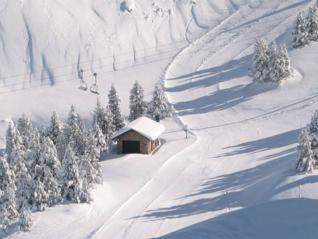


America’s Next Indoor Snow Centre Takes Shape
Construction of a new indoor snow centre for skiers, boarders and tubers appears to be making good progress at Heritage Farm in Wayne County, West Virginia.

Next 3 days weather summary:Mostly dry. Warm (max 25°C on Fri afternoon, min 17°C on Wed night). Winds decreasing (fresh winds from the WSW on Wed afternoon, light winds from the W by Thu night). | Days 4-6 weather summary:Moderate rain (total 11.0mm), heaviest on Sun afternoon. Very mild (max 19°C on Sat afternoon, min 10°C on Sun afternoon). Wind will be generally light. | ||||||||||||||||
Wed 22 | Thursday 23 | Friday 24 | Saturday 25 | Sunday 26 | Monday 27 | ||||||||||||
PM | night | AM | PM | night | AM | PM | night | AM | PM | night | AM | PM | night | AM | PM | night | |
clear | clear | clear | clear | clear | clear | some clouds | clear | clear | clear | clear | clear | rain shwrs | rain shwrs | clear | clear | clear | |
km/h | |||||||||||||||||
Snow map |  | 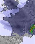 |  | 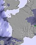 | 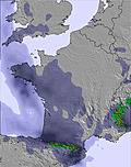 |  | |||||||||||
— | — | — | — | — | — | — | — | — | — | — | — | — | — | — | — | — | |
mm | — | — | — | — | — | — | — | — | — | — | — | — | 6 | 5 | — | — | — |
max °C | 24 | 21 | 21 | 24 | 22 | 21 | 25 | 21 | 19 | 19 | 17 | 14 | 15 | 11 | 15 | 19 | 17 |
min °C | 22 | 17 | 18 | 23 | 18 | 18 | 24 | 18 | 17 | 19 | 11 | 11 | 10 | 10 | 11 | 17 | 14 |
chill °C | 22 | 17 | 18 | 23 | 18 | 18 | 24 | 18 | 16 | 18 | 11 | 11 | 10 | 9 | 10 | 17 | 14 |
Humid % | 27 | 42 | 32 | 24 | 35 | 27 | 21 | 37 | 25 | 18 | 56 | 53 | 82 | 62 | 41 | 41 | 60 |
Freeze m | 4850 | 4800 | 4650 | 4800 | 4800 | 4800 | 4900 | 4750 | 4400 | 4350 | 3950 | 3750 | 3800 | 4200 | 4350 | 4650 | 4950 |
— | — | 6:35 | — | — | 6:35 | — | — | 6:37 | — | — | 6:37 | — | — | 6:39 | — | — | |
— | 9:22 | — | — | 9:21 | — | — | 9:20 | — | — | 9:19 | — | — | 9:17 | — | — | 9:16 | |
Go pro and carve into:
Avalanche information: European Avalanche Warning Services (EAWS)
Latest snow reports near Masella:
| Top snow depth: | 0 cm |
|---|---|
| Bottom snow depth: | 0 cm |
| Fresh snowfall depth: | — |
| Last snowfall: | 17 May 2026 |
| Snow Alerts | Create Alert |
0.0 | Bluebird Powder days Fresh snow, mostly sunny, light wind. |
|---|---|
0.0 | Powder days Fresh snow, limited sun, any wind. |
0.0 | Bluebird days Average snow, mostly sunny, light wind. |
The above table gives the weather forecast for Masella at the specific elevation of 2068 m. Our sophisticated weather models allow us to provide snow forecasts for the top, middle and bottom ski stations of Masella. To access the weather forecasts for the other elevations, use the tab navigation above the table. For a wider view of the weather, check out the Weather Map of Spain.
Click here to read further information on freezing levels and how we forecast our temperatures.
Overall 3.7 Based on 38 votes and 4 reviews
Positive: - Near Barcelona city (about 2 hours drive one way, but you must pay a total of 32 Euros toll for a total of 4 tunnels both ways. Yes, you could drive with no toll on a small road, but then is 3 hours one way). - Trails usually well groomed. - Usually good weather (but the better the weather, the worse the snow). Negative: - Masella lies on a north face, so there is no sun (at all) in December and January. - Little lodge and eating facilities on or near slopes. - Web page and phone operators always overrated snow deep, number of open slopes, and weather and wind conditions (lift closures). - Personnel unfriendly. - Snowpark is small and not well prepared. - Small ski station (can be very crowded at weekends and holidays). - Very expensive lifts (41 Euros daily, in 2014, without slope insurance; much more expensive that any comparable ski station in Spain and on the Alps).
Skier from Barcelona from Spain writes:
Positive:
- Near Barcelona city (about 2 hours drive one way, but you must pay a total of 32 Euros toll for a total of 4 tunnels both ways. Yes, you could drive with no toll on a small road, but then is 3 hours one way).
- Trails usually well groomed.
- Usually good weather (but the better the weather, the worse the snow).
Negative:
- Masella lies on a north face, so there is no sun (at all) in December and January.
- Little lodge and eating facilities on or near slopes.
- Web page and phone operators always overrated snow deep, number of open slopes, and weather and wind conditions (lift closures).
- Personnel unfriendly.
- Snowpark is small and not well prepared.
- Small ski station (can be very crowded at weekends and holidays).
- Very expensive lifts (41 Euros daily, in 2014, without slope insurance; much more expensive that any comparable ski station in Spain and on the Alps).


 Nearest