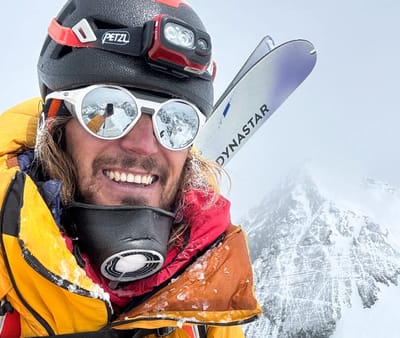
snowy resort image
Ski France

Les Karellis Snow Forecast

Weather Forecast for Les Karellis at 1600 m
Issued: 12 pm  23 Jan 2026 (local time)

New snow in Les Karellis

0.5cm0.2in
Fri 23rd (PM)
The snow forecast for Les Karellis is: A dusting of new snow. Freeze-thaw conditions (max 1°C on Fri morning, min -9°C on Sun night). Wind will be generally light.

Les Karellis Weather (Next 3 days): The snow forecast for Les Karellis is: A dusting of new snow. Freeze-thaw conditions (max 1°C on Fri morning, min -9°C on Sun night). Wind will be generally light.

Les Karellis Weather (Days 4-6): Drizzle on Tue morning followed by colder weather and a heavy fall of snow, heaviest during Tue night. Freeze-thaw conditions (max 1°C on Tue morning, min -11°C on Mon night). Wind will be generally light.


Les Karellis Live Weather

ResortSnow DepthTemp. (°C)Wind (km/h)Weather
Top Lift: 1.4m
-5
20
snow showers
Middle Lift: 
-2
15
snow showers
Bottom Lift: 0.7m
1
10
part cloud
6 Day Forecast
Issued: 12 pm 23 Jan 2026 / Updates in ::
Change Forecast Height
Choose Forecast
Last 6 daysScroll left for last 6 daysNow
Friday
23
Saturday
24
Sunday
25
Monday
26
Tuesday
27
Wednesday
28
AM
PM
night
AM
PM
night
AM
PM
night
AM
PM
night
AM
PM
night
AM
PM
night
cloud
snow showers
light snow
clear
cloud
light snow
light snow
light snow
light snow
light snow
light snow
part cloud
light snow
light snow
heavy snow
mod snow
light snow
snow showers
cloudy
snow shwrs
light snow
clear
cloudy
light snow
light snow
light snow
light snow
light snow
light snow
some clouds
light snow
light snow
heavy snow
mod. snow
light snow
snow shwrs
 km/h
10
SSE
10
SSE
5
SE
10
SE
5
ESE
5
ESE
5
NNW
10
NW
0
S
10
NNW
10
NNW
5
SSE
10
SSE
15
SSE
15
SSE
10
NW
10
NNW
5
N
Snow map
2
1
3
21
5
2
1
1
max °C
1
1
-5
0
0
-4
-2
-2
-4
-3
-3
-4
1
0
-4
-4
-4
-8
min °C
-2
-5
-7
-4
-5
-5
-3
-5
-9
-5
-6
-11
0
-3
-4
-4
-6
-11
-6
-10
-11
-8
-9
-9
-5
-8
-9
-9
-9
-15
-3
-8
-9
-9
-11
-11
81
85
94
84
74
83
95
90
91
94
85
60
56
92
92
96
95
92
1500
1750
950
1100
1600
950
1100
1300
600
900
1150
250
1850
1950
1050
1000
950
450
Sea lvl1000m2000m3000m4000m5000m
-5-6-8-7-7-8-9-9-10-10-8-5-3-3-7-11-11-10-1-2-6-2-3-5-3-4-7-4-5-81-2-4-4-5-10
Sunrise
8:03
8:03
8:02
8:00
8:00
7:58
Sunset
5:28
5:29
5:30
5:31
5:32
5:35

Snow Radar

Submit a report Eyeball Reporter

Latest snow reports near Les Karellis:

  • 42 km away from Les Karellis

    2 hours ago
    Is it snowing?

    It is snowing steadily in Sauze d'Oulx (Vialattea). from Sauze d'Oulx (Vialattea)

  • 42 km away from Les Karellis

    7 hours ago
    Is it snowing?

    Heavy snow is falling in Montgenèvre (Vialattea). from Montgenèvre (Vialattea)

  • 15 km away from Les Karellis

    - Office de Tourisme de Val Thorens8 hours ago
    Eyeball reporter

    All lifts open, perfect snow conditions. Overcast skies, low temperatures. from Val Thorens

Les Karellis Snow Conditions

Top snow depth:140cm
Bottom snow depth:70cm
Fresh snowfall depth:2cm
Last snowfall:22 Jan 2026
Snow AlertsCreate Alert
Other resorts in France are reporting: powder (26) / good piste (31)


Snow History

Week 4 of January has on average:
0.3
Bluebird Powder days
Fresh snow, mostly sunny, light wind.
1.8
Powder days
Fresh snow, limited sun, any wind.
0.8
Bluebird days
Average snow, mostly sunny, light wind.


Snow-Forecast Partner Offers