The snow forecast for Les Deux Alpes is: A dusting of new snow. Temperatures will be well below freezing (max -7°C on Fri morning, min -11°C on Sun night). Wind will be generally light.
Les Deux Alpes Weather (Next 3 days): The snow forecast for Les Deux Alpes is: A dusting of new snow. Temperatures will be well below freezing (max -7°C on Fri morning, min -11°C on Sun night). Wind will be generally light.
Les Deux Alpes Weather (Days 4-6): A light covering of new snow, mostly falling on Wed night. Temperatures will be well below freezing (max -10°C on Mon morning, min -11°C on Mon morning). Wind will be generally light.
Issued by Snow-Forecast.com at:12 pm (local time) / 06 Mar 2026
Les Deux Alpes Weather
(Next 3 days):
The snow forecast for Les Deux Alpes is: A dusting of new snow. Temperatures will be well below freezing (max -7°C on Fri morning, min -11°C on Sun night). Wind will be generally light.
Les Deux Alpes Weather (Days 4-6):
A light covering of new snow, mostly falling on Wed night. Temperatures will be well below freezing (max -10°C on Mon morning, min -11°C on Mon morning). Wind will be generally light.
Les Deux Alpes Weather (Days 7-16):
Interested in the 16-day Forecast? Unlock the full forecast and many more features by becoming a Pro member.
A dusting of new snow. Temperatures will be well below freezing (max -7°C on Fri morning, min -11°C on Sun night). Wind will be generally light.
Next 4-6 days weather summary:
A light covering of new snow, mostly falling on Wed night. Temperatures will be well below freezing (max -10°C on Mon morning, min -11°C on Mon morning). Wind will be generally light.
The above table gives the weather forecast for Les Deux Alpes at the specific elevation of 3600 m. Our sophisticated weather models allow us to provide snow forecasts for the top, middle and bottom ski stations of Les Deux Alpes. To access the weather forecasts for the other elevations, use the tab navigation above the table. For a wider view of the weather, check out the Weather Map of France.
Click here to read further information on freezing levels and how we forecast our temperatures.
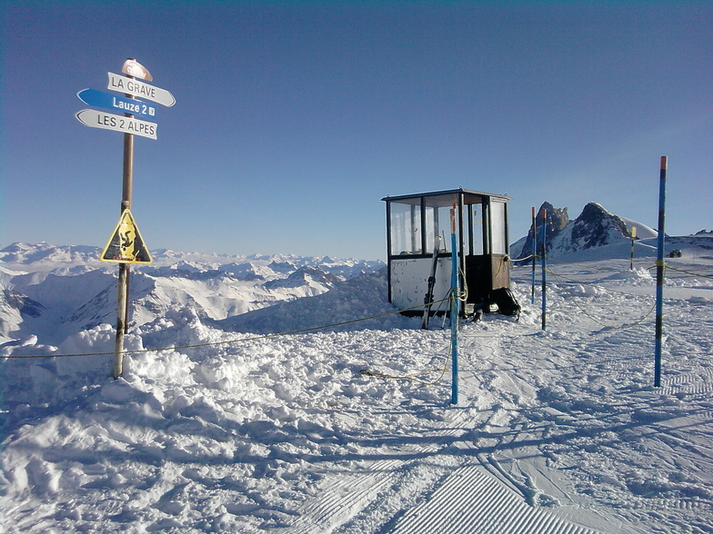
I did about a month in Les 2 Alpes region earlier this season. From what I've read of the reviews they seem mostly fair. I would say that the resort is great for the experienced skier or boarder. Particularly if you like park skiing as I do. Their large line is really nicely shaped. I can say one other comment here was correct about stones in the line, but it has not been a significant snowfall season again in much of the French Alps, so I figure this is why. Probably not representative of typical season. And once I fished most of them out, no problem. I would say they tend to close the main line too early in the day though, as every day it was closed by 1500, which in many cases is the best part of the day as the landings may start to soften a bit by then. The main issue for most people in Les 2 Alpes is likely to be the runs back to town. I saw many people returning using the chairlifts which says it all really. The runs for the non expert back to town are all narrow road/tracks cut into the side of the mountain, which is rather steep. So most beginners or less experienced skiers will not enjoy this as it can be very crowded. For off-piste, if you get the snow, there is a lot to like here, plenty good terrain around. I would say that if you're a boarder you may get a bit frustrated by the large number of traversing roads that are pretty flat which move you round between the sectors, as everything is along on valley essentially.
For the ladies, I'm not really sure what you are going to do for toilets on mountain, I only saw one or two about, and loads of pee spots at the side of runs, way more of this than I've seen anywhere else.... And the public facilities I ventured into are like you may expect to find in a prison cell. Not up the standards of on mountain facilities you would expect these days, and definitely not enough of them. Similarly I would say on-mountain food options are pretty limited in number and you could, if so inclined, waste an hour waiting to get served.
The town itself is rather nice and they seem to be updating many of the older buildings currently and it is a fair bit prettier than say Les Menuires or Tignes Val Claret, for example. Food wise, there are loads of pubs and restaurants for all budget, plenty cheap eats too, and the takeaway pizzas can be great (Le Chalet a Pizza is excellent and reasonable prices too).
The only problem I would say you may have regarding the town is accommodation. It's not likely to be ski-in ski-out as most of the places are not right on piste. If you are a skier you may want some Siddas snow-trax for your boots to avoid them getting the contact plates for the bindings on the soles ruined by walking around on tarmac and concrete.
Free Snow-Forecast.com weather widget for your website
Embed the Les Deux Alpes weather widget on your site for free. It provides a weekly snapshot of snow and rain conditions across all elevations. Follow the two quick steps to grab your custom code and paste it into your site. Choose between metric or imperial units. Click here to get the code.


 Nearest