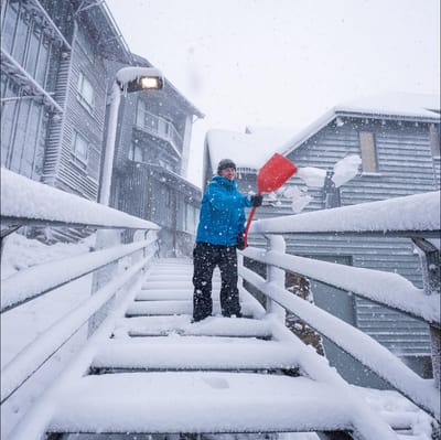
"March Madness" As Snowfall Hits Australia In Early Autumn
Winter made an early-season entrance in Australia overnight, with a polar blast from the Antarctic dumping up to 15cm of fresh snow on the slopes as temperatures tumbled to around -2.C.


Le Sappey Weather (Next 3 days): The snow forecast for Le Sappey is: Mostly dry. Freeze-thaw conditions (max 5°C on Thu afternoon, min -3°C on Tue night). Winds decreasing (strong winds from the NNE on Tue night, light winds from the NE by Wed night).
Le Sappey Weather (Days 4-6): Mostly dry. Very mild (max 14°C on Sun afternoon, min 1°C on Fri night). Wind will be generally light.
| Resort | Snow Depth | Temp. (°C) | Wind (km/h) | Weather | ||
|---|---|---|---|---|---|---|
| Top Lift: | -5 | |||||
| Middle Lift: | -2 | |||||
| Bottom Lift: | 2 |

Tue 31 | Wednesday 1 | Thursday 2 | Friday 3 | Saturday 4 | Sunday 5 | ||||||||||||
PM | night | AM | PM | night | AM | PM | night | AM | PM | night | AM | PM | night | AM | PM | night | |
some clouds | some clouds | some clouds | cloudy | some clouds | cloudy | some clouds | clear | clear | clear | clear | clear | clear | clear | clear | clear | some clouds | |
km/h | |||||||||||||||||
Snow map |  |  |  |  |  |  | |||||||||||
— | — | — | — | — | — | — | — | — | — | — | — | — | — | — | — | — | |
— | — | — | — | — | — | — | — | — | — | — | — | — | — | — | — | — | |
max °C | 3 | 0 | 1 | 4 | 1 | 0 | 5 | 3 | 4 | 8 | 4 | 6 | 10 | 7 | 11 | 14 | 10 |
min °C | 2 | -3 | -3 | 3 | -2 | -2 | 4 | -1 | -1 | 7 | 1 | 2 | 9 | 5 | 5 | 13 | 6 |
-4 | -10 | -10 | -2 | -6 | -7 | -1 | -6 | -6 | 4 | -3 | -2 | 9 | 2 | 3 | 13 | 5 | |
61 | 77 | 75 | 57 | 84 | 88 | 67 | 82 | 74 | 59 | 75 | 57 | 54 | 64 | 43 | 45 | 72 | |
1200 | 700 | 950 | 1350 | 850 | 900 | 1600 | 1300 | 1350 | 2100 | 2050 | 2400 | 2650 | 2950 | 2750 | 2800 | 2850 | |
— | — | 7:16 | — | — | 7:13 | — | — | 7:11 | — | — | 7:09 | — | — | 7:07 | — | — | |
— | 8:00 | — | — | 8:02 | — | — | 8:04 | — | — | 8:05 | — | — | 8:07 | — | — | 8:07 | |
Mostly dry. Freeze-thaw conditions (max 5°C on Thu afternoon, min -3°C on Tue night). Winds decreasing (strong winds from the NNE on Tue night, light winds from the NE by Wed night).
Mostly dry. Very mild (max 14°C on Sun afternoon, min 1°C on Fri night). Wind will be generally light.
Latest snow reports near Le Sappey:
Ski resort closed but there is still a lot of snow. from La Giettaz en Aravis
Snowing in Avoriaz. from Avoriaz
Intermittent light rain reported from Aéroport Annecy Haute-Savoie Mont Blanc (Meythet) at 459 metres elevation only 3 kms NW of Annecy-LeSemnoz but it is forecast cold enough for snow at the ski area from Annecy-LeSemnoz
It is snowing heavily in Flaine. from Flaine
It is snowing steadily in Le Grand Bornand. from Le Grand Bornand
| Top snow depth: | — |
|---|---|
| Bottom snow depth: | — |
| Fresh snowfall depth: | 3.0 cm |
| Last snowfall: | 30 Mar 2026 |
| Snow Alerts | Create Alert |
0.0 | Bluebird Powder days Fresh snow, mostly sunny, light wind. |
|---|---|
0.4 | Powder days Fresh snow, limited sun, any wind. |
0.0 | Bluebird days Average snow, mostly sunny, light wind. |
The above table gives the weather forecast for Le Sappey at the specific elevation of 1000 m. Our sophisticated weather models allow us to provide snow forecasts for the top, middle and bottom ski stations of Le Sappey. To access the weather forecasts for the other elevations, use the tab navigation above the table. For a wider view of the weather, check out the Weather Map of France.
Click here to read further information on freezing levels and how we forecast our temperatures.


 Nearest