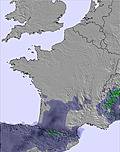
The snow forecast for Le Lioran is: Light rain (total 7.0mm), mostly falling on Fri afternoon. Mild temperatures (max 9°C on Fri morning, min 3°C on Sat night). Wind will be generally light.
Le Lioran Weather (Next 3 days): The snow forecast for Le Lioran is: Light rain (total 7.0mm), mostly falling on Fri afternoon. Mild temperatures (max 9°C on Fri morning, min 3°C on Sat night). Wind will be generally light.
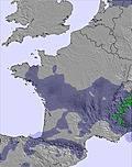
Le Lioran Weather (Days 4-6): Heavy rain (total 38.0mm), heaviest during Mon night. Mild temperatures (max 7°C on Wed morning, min 2°C on Tue night). Wind will be generally light.
Issued by Snow-Forecast.com at:12 pm (local time) / 06 Mar 2026
Le Lioran Weather
(Next 3 days):
The snow forecast for Le Lioran is: Light rain (total 7.0mm), mostly falling on Fri afternoon. Mild temperatures (max 9°C on Fri morning, min 3°C on Sat night). Wind will be generally light.
Le Lioran Weather (Days 4-6):
Heavy rain (total 38.0mm), heaviest during Mon night. Mild temperatures (max 7°C on Wed morning, min 2°C on Tue night). Wind will be generally light.
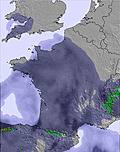
Le Lioran Weather (Days 7-16):
Interested in the 16-day Forecast? Unlock the full forecast and many more features by becoming a Pro member.
Light rain (total 7.0mm), mostly falling on Fri afternoon. Mild temperatures (max 9°C on Fri morning, min 3°C on Sat night). Wind will be generally light.
Next 4-6 days weather summary:
Heavy rain (total 38.0mm), heaviest during Mon night. Mild temperatures (max 7°C on Wed morning, min 2°C on Tue night). Wind will be generally light.
The above table gives the weather forecast for Le Lioran at the specific elevation of 1172 m. Our sophisticated weather models allow us to provide snow forecasts for the top, middle and bottom ski stations of Le Lioran. To access the weather forecasts for the other elevations, use the tab navigation above the table. For a wider view of the weather, check out the Weather Map of France.
Click here to read further information on freezing levels and how we forecast our temperatures.
Lioran is good value - stunningly good by the standards of the Alps. However, remember tht it isn't the Alps - which means that there are some good and some bad things. Good things - empty during the week, lift prices very fair as are equipment prices, cheap food, coffee etc and accomodation you can swing a cat in is the norm. Bad things - it's a small area and if some of it is closed you can get a bit limited, they don't snowplough in the station itself - so take snow chains (and know how to use them as you will have to stop going uphill as the downcoming traffic won't)if you have accomodation other than in the centre, some of the runs require a knowledge of when to let go and go for the lift if you are to avoid poling or walking. Weekends are mobbed from mid morning so arrive early, break before lunch (as the rest of the slopes head for the bars at 11.55 precisely and stay there for two hours) ski over lunch and head out for lunch after the bars empty. Or just join them and have fun in the bars. Eat truffade but avoid the tripe.
For ski value - cracking. For atmosphere and sophistication - well, your call.
Free Snow-Forecast.com weather widget for your website
Embed the Le Lioran weather widget on your site for free. It provides a weekly snapshot of snow and rain conditions across all elevations. Follow the two quick steps to grab your custom code and paste it into your site. Choose between metric or imperial units. Click here to get the code.


 Nearest