

Portillo Storm Snowfall Total Passes 5m / 17 Feet
A snow storm that has now continued for nine days has taken Chilean ski resort Portillo to a snowfall total of 5.2 metres (17 feet) so far, with more snow forecast.

Next 3 days weather summary:Heavy rain (total 69.0mm), heaviest during Wed morning. Warm (max 27°C on Mon afternoon, min 16°C on Mon night). Wind will be generally light. | Days 4-6 weather summary:Heavy rain (total 20.0mm), heaviest during Fri afternoon. Warm (max 25°C on Sat afternoon, min 15°C on Fri night). Wind will be generally light. | ||||||||||||||||
Mon 27 | Tuesday 28 | Wednesday 29 | Thursday 30 | Friday 31 | Saturday 1 | ||||||||||||
PM | night | AM | PM | night | AM | PM | night | AM | PM | night | AM | PM | night | AM | PM | night | |
rain shwrs | rain shwrs | some clouds | mod. rain | mod. rain | heavy rain | t-storm risk | heavy rain | mod. rain | light rain | light rain | light rain | light rain | rain shwrs | light rain | rain shwrs | rain shwrs | |
km/h | |||||||||||||||||
Snow map |  |  |  |  |  |  | |||||||||||
— | — | — | — | — | — | — | — | — | — | — | — | — | — | — | — | — | |
mm | 1 | 3 | — | 6 | 8 | 21 | 4 | 17 | 9 | 2 | 4 | 2 | 5 | 2 | 1 | 3 | 1 |
max °C | 27 | 20 | 25 | 21 | 19 | 18 | 20 | 18 | 17 | 19 | 17 | 21 | 22 | 19 | 23 | 25 | 20 |
min °C | 26 | 16 | 18 | 20 | 18 | 18 | 19 | 17 | 17 | 18 | 16 | 17 | 22 | 15 | 18 | 25 | 17 |
chill °C | 26 | 16 | 18 | 20 | 18 | 18 | 19 | 17 | 17 | 18 | 16 | 17 | 22 | 15 | 18 | 25 | 17 |
Humid % | 50 | 83 | 67 | 91 | 98 | 98 | 95 | 99 | 99 | 90 | 97 | 83 | 77 | 94 | 75 | 68 | 95 |
Freeze m | 3600 | 3900 | 3900 | 3900 | 4000 | 3850 | 3900 | 3650 | 3650 | 3600 | 3750 | 3700 | 3850 | 4000 | 4100 | 4200 | 4300 |
— | — | 5:35 | — | — | 5:35 | — | — | 5:37 | — | — | 5:37 | — | — | 5:39 | — | — | |
— | 8:20 | — | — | 8:19 | — | — | 8:17 | — | — | 8:15 | — | — | 8:15 | — | — | 8:14 | |
Go pro and carve into:
Avalanche information: National Avalanche Center
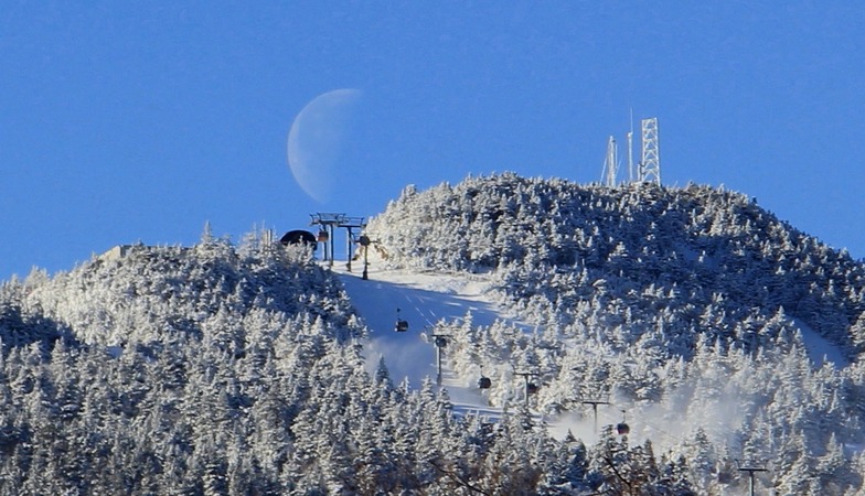
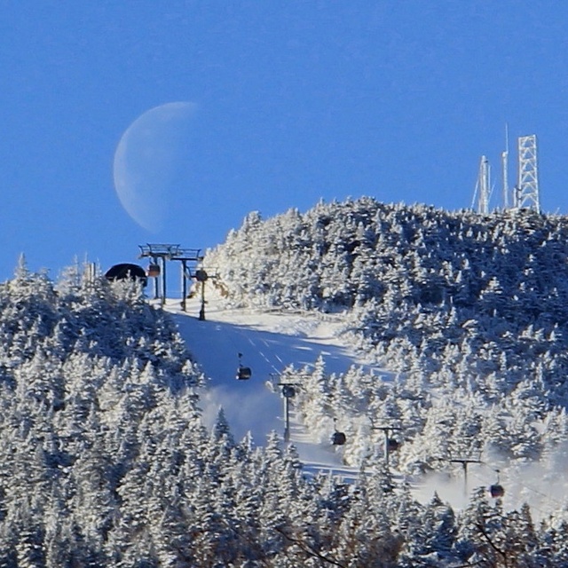
Latest snow reports near Killington:
| Top snow depth: | 0 cm |
|---|---|
| Bottom snow depth: | 0 cm |
| Fresh snowfall depth: | — |
| Last snowfall: | 30 May 2026 |
| Snow Alerts | Create Alert |
0.0 | Bluebird Powder days Fresh snow, mostly sunny, light wind. |
|---|---|
0.0 | Powder days Fresh snow, limited sun, any wind. |
0.0 | Bluebird days Average snow, mostly sunny, light wind. |
The above table gives the weather forecast for Killington at the specific elevation of 329 m. Our sophisticated weather models allow us to provide snow forecasts for the top, middle and bottom ski stations of Killington. To access the weather forecasts for the other elevations, use the tab navigation above the table. For a wider view of the weather, check out the Weather Map of United States.
Click here to read further information on freezing levels and how we forecast our temperatures.
Overall 3.9 Based on 30 votes and 53 reviews
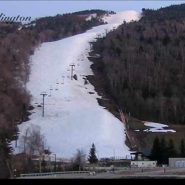
Construction still has things up in the air at Killington this season. Well, that and the rainy weather. Weather delays has construction behind schedule, with lifts and ski tunnels not yet complete with ski season upon us. Killington is operating the gondola and an upper mountain lift with no top to bottom skiing. TTB route is in flux due to ongoing construction and it's yet to be seen what Killington will do as a work around. World Cup skiing arrives in 2 weeks, with Superstar not yet in race condition and no top to bottom skiing. Has Killington backed itself between a rock and a hard place? Pretty poor planning if you ask me...
Alan from United States writes:
Construction still has things up in the air at Killington this season. Well, that and the rainy weather. Weather delays has construction behind schedule, with lifts and ski tunnels not yet complete with ski season upon us. Killington is operating the gondola and an upper mountain lift with no top to bottom skiing. TTB route is in flux due to ongoing construction and it's yet to be seen what Killington will do as a work around. World Cup skiing arrives in 2 weeks, with Superstar not yet in race condition and no top to bottom skiing. Has Killington backed itself between a rock and a hard place? Pretty poor planning if you ask me...


 Nearest