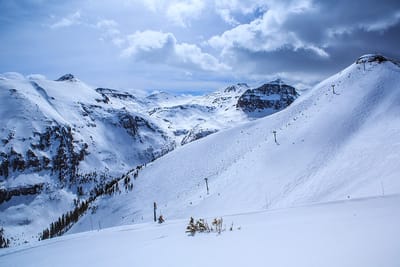
snowy resort image
Ski Canada - Ontario

Dagmar Ski Resort Snow Forecast

Weather Forecast for Dagmar Ski Resort at 91 m
Issued: 6 am  09 Nov 2025 (local time)

New snow in Dagmar Ski Resort

3.0cm1.2in
Sun 9th (AM)
The snow forecast for Dagmar Ski Resort is: A light covering of new snow on Sun afternoon turning to drizzle on Tue morning. Freeze-thaw conditions (max 3°C on Tue afternoon, min -5°C on Mon night). Wind will be generally light.

Dagmar Ski Resort Weather (Next 3 days): The snow forecast for Dagmar Ski Resort is: A light covering of new snow on Sun afternoon turning to drizzle on Tue morning. Freeze-thaw conditions (max 3°C on Tue afternoon, min -5°C on Mon night). Wind will be generally light.

Dagmar Ski Resort Weather (Days 4-6): Light rain (total 9.0mm), mostly falling on Wed morning. Freeze-thaw conditions (max 6°C on Fri morning, min -3°C on Fri night). Wind will be generally light.


Dagmar Ski Resort Live Weather

ResortSnow DepthTemp. (°C)Wind (km/h)Weather
Top Lift: 0.0m
-1
20
light snow
Bottom Lift: 0.0m
0
20
light snow
6 Day Forecast
Issued: 6 am 09 Nov 2025 / Updates in ::
Change Forecast Height
Choose Forecast
Last 6 daysScroll left for last 6 daysNow
Sunday
9
Monday
10
Tuesday
11
Wednesday
12
Thursday
13
Friday
14
Saturday
15
AM
PM
night
AM
PM
night
AM
PM
night
AM
PM
night
AM
PM
night
AM
PM
night
AM
PM
night
light snow
light snow
light snow
light snow
light snow
light snow
snow showers
cloud
light snow
light rain
light rain
snow showers
rain showers
rain showers
clear
rain showers
clear
part cloud
cloud
light snow
light snow
light snow
light snow
light snow
light snow
light snow
light snow
snow shwrs
cloudy
light snow
light rain
light rain
snow shwrs
rain shwrs
rain shwrs
clear
rain shwrs
clear
some clouds
cloudy
light snow
light snow
 km/h
20
NE
20
N
20
NNW
20
NNW
20
NNW
10
WNW
15
WNW
15
W
20
SW
20
WSW
25
W
10
NW
15
WNW
15
W
10
W
15
WNW
10
NNW
5
NE
15
ESE
20
ESE
20
ESE
Snow map
 cm 
2
1
1
1
3
 mm 
1
2
2
1
1
2
1
4
max°C
0
-1
-3
-3
-3
-3
2
3
3
4
5
4
5
4
1
6
4
-2
2
2
4
min°C
-1
-3
-4
-4
-4
-5
-2
1
0
3
5
0
3
3
1
3
0
-3
-1
1
2
chill°C 
-7
-10
-10
-10
-9
-9
-7
-3
-5
-1
1
-4
-1
-1
-2
0
-3
-6
-5
-4
-3
Humid% 
81
92
88
86
79
83
87
76
97
95
90
98
82
83
86
79
69
82
74
77
97
Freezing level (m
0
0
0
0
0
0
0
450
200
650
850
250
500
600
300
850
800
0
0
2400
2950
topliftbotliftSea lvl1000m2000m3000m4000m5000m
-1-2-4-4-4-402245244152-31230-2-4-3-3-412245254152-4011
Sunrise
7:01
7:03
7:05
7:05
7:07
7:09
7:09
Sunset
4:55
4:53
4:52
4:52
4:51
4:50
4:49

Snow Radar

Submit a report Eyeball Reporter

Latest snow reports near Dagmar Ski Resort:

  • 14 km away from Dagmar Ski Resort

    3 hours ago
    weather station observation

    Continuous light snow reported from Oshawa at 133 metres elevation only 3 kms NW of Oshawa Ski Club Ski Resort from Oshawa Ski Club

  • 14 km away from Dagmar Ski Resort

    4 hours ago
    weather station observation

    Light snow reported from Oshawa Airport at 139 metres elevation only 3 kms WNW of Oshawa Ski Club Ski Resort from Oshawa Ski Club

Dagmar Ski Resort Snow Conditions

Top snow depth:0cm
Bottom snow depth:0cm
Fresh snowfall depth:
Last snowfall:10 Apr 2025
Snow AlertsCreate Alert
Other resorts in Canada - Ontario are reporting: powder (0) / good piste (0)


Snow History

Week 2 of November has on average:
0.0
Bluebird Powder days
Fresh snow, mostly sunny, light wind.
0.0
Powder days
Fresh snow, limited sun, any wind.
0.1
Bluebird days
Average snow, mostly sunny, light wind.


Snow-Forecast Partner Offers