

Portillo Storm Snowfall Total Passes 5m / 17 Feet
A snow storm that has now continued for nine days has taken Chilean ski resort Portillo to a snowfall total of 5.2 metres (17 feet) so far, with more snow forecast.

Next 4 days weather summary:Moderate rain (total 10.0mm), heaviest on Mon night. Warm (max 22°C on Mon night, min 16°C on Tue night). Winds increasing (calm on Mon night, fresh winds from the N by Wed morning). | Days 5-7 weather summary:Light rain (total 4.0mm), mostly falling on Sun morning. Warm (max 25°C on Sat afternoon, min 17°C on Thu night). Wind will be generally light. | |||||||||||||||
Tuesday 28 | Wednesday 29 | Thursday 30 | Friday 31 | Saturday 1 | ||||||||||||
night | AM | PM | night | AM | PM | night | AM | PM | night | AM | PM | night | AM | PM | night | |
rain shwrs | some clouds | cloudy | some clouds | clear | clear | clear | clear | clear | clear | clear | some clouds | some clouds | clear | some clouds | some clouds | |
km/h | ||||||||||||||||
Snow map |  |  |  |  |  |  | ||||||||||
— | — | — | — | — | — | — | — | — | — | — | — | — | — | — | — | |
mm | 10 | — | — | — | — | — | — | — | — | — | — | — | — | — | — | — |
max °C | 22 | 19 | 19 | 17 | 17 | 20 | 20 | 19 | 22 | 21 | 22 | 24 | 21 | 23 | 25 | 22 |
min °C | 19 | 19 | 19 | 16 | 16 | 19 | 16 | 17 | 20 | 17 | 18 | 24 | 19 | 20 | 22 | 20 |
chill °C | 19 | 19 | 19 | 14 | 14 | 18 | 16 | 17 | 20 | 17 | 18 | 24 | 19 | 20 | 22 | 20 |
Humid % | 84 | 86 | 78 | 75 | 71 | 56 | 74 | 60 | 49 | 54 | 52 | 54 | 72 | 60 | 67 | 71 |
Freeze m | 4050 | 3850 | 3900 | 3950 | 3850 | 3800 | 3900 | 4000 | 4150 | 4300 | 4350 | 4300 | 4250 | 4100 | 3950 | 3900 |
— | 6:01 | — | — | 6:03 | — | — | 6:03 | — | — | 6:05 | — | — | 6:07 | — | — | |
— | — | — | 8:51 | — | — | 8:50 | — | — | 8:47 | — | — | 8:46 | — | — | 8:45 | |
Go pro and carve into:
Avalanche information: Avalanche Canada
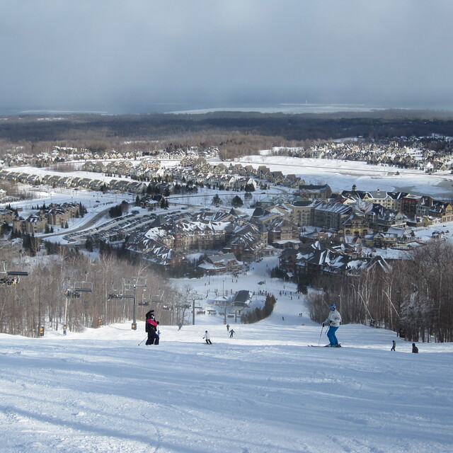
Latest snow reports near Blue Mountain:
| Top snow depth: | 0 cm |
|---|---|
| Bottom snow depth: | 0 cm |
| Fresh snowfall depth: | — |
| Last snowfall: | 10 Apr 2026 |
| Snow Alerts | Create Alert |
0.0 | Bluebird Powder days Fresh snow, mostly sunny, light wind. |
|---|---|
0.0 | Powder days Fresh snow, limited sun, any wind. |
0.0 | Bluebird days Average snow, mostly sunny, light wind. |

The above table gives the weather forecast for Blue Mountain at the specific elevation of 450 m. Our sophisticated weather models allow us to provide snow forecasts for the top, middle and bottom ski stations of Blue Mountain. To access the weather forecasts for the other elevations, use the tab navigation above the table. For a wider view of the weather, check out the Weather Map of Canada.
Click here to read further information on freezing levels and how we forecast our temperatures.
Overall 3.6 Based on 18 votes and 2 reviews
Overall good resort. Nothing compared to big places out east and west but it is probably best and biggest in Ontario. Good variety of terrain, although all the steeps are very short. If it's your first time there you will love it, if you've been to a bigger place you will think it is average. Nuff said
Patrick from Canada writes:
Overall good resort. Nothing compared to big places out east and west but it is probably best and biggest in Ontario. Good variety of terrain, although all the steeps are very short. If it's your first time there you will love it, if you've been to a bigger place you will think it is average. Nuff said


 Nearest