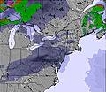
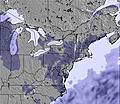
Weather Forecast for Attitash Mountain Resort at716m altitude
Issued: 1 am 14 Jun 2026 (local time)
Forecast update in hr min
View forecast
Attitash Mountain Resortat 716 m altitude
Issued by Snow-Forecast.com at:1 am (local time) / 14 Jun 2026
Last 6 daysScroll left for last 6 daysNow
Next 3 days weather summary:
Moderate rain (total 18.0mm), heaviest on Sun night. Warm (max 24°C on Sun afternoon, min 8°C on Mon night). Winds decreasing (fresh winds from the SW on Sun night, calm by Tue morning).
Days 4-6 weather summary:
Heavy rain (total 31.0mm), heaviest during Thu afternoon. Very mild (max 18°C on Wed afternoon, min 11°C on Fri night). Winds increasing (light winds from the SW on Wed night, strong winds from the W by Thu night).
The above table gives the weather forecast for Attitash Mountain Resort at the specific elevation of 716 m. Our sophisticated weather models allow us to provide snow forecasts for the top, middle and bottom ski stations of Attitash Mountain Resort. To access the weather forecasts for the other elevations, use the tab navigation above the table. For a wider view of the weather, check out the Weather Map of United States.
Click here to read further information on freezing levels and how we forecast our temperatures.
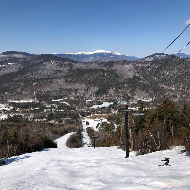
Amazing, with the amount of money this ski area takes in, that the triple chair that brings you to the summit is actually older than the Attitash ski area itself. How, you might ask, was it purchased from another ski area? This chair breaks down quite often. Attitash has a low base elevation 600 feet; more likely to get rain than some nearby ski areas with higher base elevation on borderline snow/rain events. This ski area gets extremely crowded on weekends; its best to avoid on a saturday. On the positive side, it does have overpriced slope-side lodging available.
Amazing, with the amount of money this ski area takes in, that the triple chair that brings you to the summit is actually older than the Attitash ski area itself. How, you might ask, was it purchased from another ski area? This chair breaks down quite often. Attitash has a low base elevation 600 feet; more likely to get rain than some nearby ski areas with higher base elevation on borderline snow/rain events. This ski area gets extremely crowded on weekends; its best to avoid on a saturday. On the positive side, it does have overpriced slope-side lodging available.
Free Snow-Forecast.com weather widget for your website
Embed the Attitash Mountain Resort weather widget on your site for free. It provides a weekly snapshot of snow and rain conditions across all elevations. Follow the two quick steps to grab your custom code and paste it into your site. Choose between metric or imperial units. Click here to get the code.


 Nearest