 Ski France
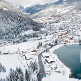
Welcome to the Ski France page, providing a regular round-up of the skiing conditions and current snow reports for the main ski resorts in the French Alps and the Pyrenees. Over recent years some of the most consistently good piste conditions have been reported at Tignes, Val d'Isere, Flaine, La Rosiere, La Plagne, Alpe d'Huez, Val Thorens and La Grave showing a mix of glacial resorts and those most exposed to the prevailing storm paths. However, in any given week or season the best slope conditions may be found at any of the other high French resorts or at lower elevation ski stations in poor weather.
For off-piste powder, resorts such as La Rosiere, Les Menuires, Morzine, Samoens, Les Saisies, Le Grand Bornand, Montchavin/Les Coches and Val d'Isere have proven among the most consistent either for their regular snowfalls, northerly aspect or for not getting tracked out quickly.
France is one of the world’s top skiing destinations. The best known of the country’s 400 or so ski areas are in the Northern and Southern Alps but there are also several dozen ski areas in the French Pyrenees and in other sectors like the Auvergne and Jura.
French ski resorts have really come in to their own in the past 40 years – later than the other three main Alpine skiing nations.
The post-war plan skiing in France was to help stop the migration of agricultural communities to the cities has been reversed by the country’s efforts to develop ski resorts. They have grown to include the world’s biggest fully lift-linked ski region (The 3 Valleys – which always had a 600km total no matter how many new runs are added); its biggest lift served vertical (at Chamonix) and indeed six of the world’s 10 biggest ski regions. Europe’s highest resort, Val Thorens, is also here.
But it’s not just size but also convenience that led many French resorts to success and ever more people to love to ski France – the original concrete resorts built in the 1960s were not always pretty but they were designed to be functional and give slopeside access to the skiing and all other facilities in a few short steps at a time when most resorts in Europe required a laborious trek to catch a ski bus and then ages on lifts getting up to the slopes.
This decision to build resorts at altitude has paid extra dividends in these years of climate change fears as, with many ski areas beginning and ending 1000 vertical metres higher than many traditional resorts, they are more likely to get natural snowfall when lower elevation resorts get rain, and for it to be cold enough to run snow making machines when lower resorts have air too warm.
Those who are not so keen on this high altitude, purpose-built ski experience however criticise the resorts as soul-less places, artificial communities (they are almost completely empty in spring and autumn) with their captive market charged high prices for a sometimes inferior service. The slopes are also criticised as bleak, being high above the treeline.
Aimed squarely at the family market, French resorts also offer the most comprehensive childcare for babies as young as a few months old at most resorts, and ski kindergarten from three, although they do make children pay for lift passes a few years younger than elsewhere in the Alps and the full adult price from early teens or younger. The family orientation also means that lively après ski is something of a rarity in France.
Although French lift passes for these big ski regions are – except when the Swiss franc is on a high – among the most expensive to ski at in Europe, the French argue that they are still the best value because your extra Euros buy access to far more kilometres of piste and the use of many more fast lifts than at smaller resorts. In any case there is usually a cheaper pass for part of the giant ski area which in any case is equal in size or larger than a ‘regular’ ski area elsewhere.
It is wrong to think however that all French resorts are purpose-built. Chamonix, Morzine, Val d'Isere, Montgenevre (Via Lattea) and many other famous resorts have long histories as mountain and ski tourism communities, some originally spa towns. Megeve was developed in the 1920s as a rival to St Moritz by Baroness Rothschild and it still retains much of the ‘old money’ and more Michelin starred chefs than any other French resort, while Courchevel has become the country’s most glitz resort where the most expensive chalet costs £200,000 a week to rent.
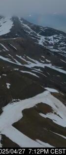
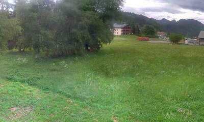
Summer glacier skiing has declined dramatically in France since 2000. There used to be 7 or 8 resorts offering summer skiing but now only three (Tignes, Val d'Isere and Les Deux Alpes) are open briefly in July and August and there’s no skiing at all in France from mid-May to late June or in September. From October to late November Tignes is the only ski area open.
For Brits, France has been the most popular destination for the past two decades taking nearly 40% of the UK market each winter. Fast motorways from the English Channel to the Alps make French resorts the easiest to reach from southern England and it’s also possible to reach many French ski areas direct by Eurostar from London St Pancras railway station.


France: latest snow conditions round-up
Summary of forecast snowfall and ski conditions for resorts in France. Fresh snow is forecast at 0 resorts. Powder is reported at 0 resorts and 0 are reporting good piste conditions.

Ski resorts in France from A to B


|
|||||||||||||||||||||||||||||||||||||
|---|---|---|---|---|---|---|---|---|---|---|---|---|---|---|---|---|---|---|---|---|---|---|---|---|---|---|---|---|---|---|---|---|---|---|---|---|---|
| Resort |

|
snow depth top and bottom |
 on-piste |
 off-piste |
 Last Snow |
Next 9 Days 0–3 | 3–6 | 6–9 snow (cm) |
 Next 7 days weather forecast.
Freezing level (m) |
||||||||||||||||||||||||||||||
| Sun | Mon | Tue | Wed | Thu | Fri | Sat | |||||||||||||||||||||||||||||||
|
(950 m — 2001 m) |
|
|
|||||||||||||||||||||||||||||||||||
|
(1550 m — 2451 m) |
|
|
|
||||||||||||||||||||||||||||||||||
|
(1000 m — 1900 m) |
|
|
|
||||||||||||||||||||||||||||||||||
|
(1500 m — 2201 m) |
|
|
|
||||||||||||||||||||||||||||||||||
|
(1100 m — 3350 m) snow report 4 days ago |
|
|
|
||||||||||||||||||||||||||||||||||
|
(1367 m — 2200 m) snow report 4 days ago |
|
|
|||||||||||||||||||||||||||||||||||
|
(1251 m — 1808 m) snow report 4 days ago |
|
|
|
||||||||||||||||||||||||||||||||||
|
(1400 m — 1700 m) |
|
|
|||||||||||||||||||||||||||||||||||
|
(1050 m — 2300 m) snow report 4 days ago |
|
|
|
||||||||||||||||||||||||||||||||||
|
(1252 m — 3275 m) snow report 4 days ago |
|
|
|||||||||||||||||||||||||||||||||||
|
(1400 m — 2100 m) |
|
|
|||||||||||||||||||||||||||||||||||
|
(1681 m — 2111 m) |
|
|
|||||||||||||||||||||||||||||||||||
|
(1500 m — 2000 m) |
|
|
|||||||||||||||||||||||||||||||||||
|
(1400 m — 1800 m) |
|
|
|||||||||||||||||||||||||||||||||||
|
(1600 m — 3330 m) |
|
|
|||||||||||||||||||||||||||||||||||
|
(1600 m — 2450 m) snow report 4 days ago |
|
|
|
||||||||||||||||||||||||||||||||||
|
(1500 m — 2750 m) snow report 4 days ago |
|
|
|
||||||||||||||||||||||||||||||||||
|
(1050 m — 1710 m) |
|
|
|||||||||||||||||||||||||||||||||||
|
(1144 m — 2254 m) snow report 4 days ago |
|
|
|
||||||||||||||||||||||||||||||||||
|
(1400 m — 2399 m) snow report 4 days ago |
|
|
|||||||||||||||||||||||||||||||||||
|
(850 m — 1237 m) snow report 4 days ago |
|
|
|||||||||||||||||||||||||||||||||||
|
(1000 m — 1301 m) |
|
|
|||||||||||||||||||||||||||||||||||
|
(1101 m — 1801 m) |
|
|
|
||||||||||||||||||||||||||||||||||
|
(1001 m — 1912 m) snow report 4 days ago |
|
|
|
||||||||||||||||||||||||||||||||||
|
(1740 m — 2200 m) |
|
|
|
||||||||||||||||||||||||||||||||||
|
(1350 m — 1849 m) snow report 4 days ago |
|
|
|||||||||||||||||||||||||||||||||||
|
(1430 m — 1725 m) |
|
|
|||||||||||||||||||||||||||||||||||
|
(1700 m — 2001 m) |
|
|
|||||||||||||||||||||||||||||||||||
|
(1801 m — 3001 m) snow report 4 days ago |
|
|
|||||||||||||||||||||||||||||||||||
|
(900 m — 1351 m) |
|
|
|||||||||||||||||||||||||||||||||||
|
(1200 m — 1600 m) |
|
|
|||||||||||||||||||||||||||||||||||
|
(1030 m — 2525 m) snow report 4 days ago |
|
|
|
||||||||||||||||||||||||||||||||||
|
(1200 m — 2501 m) |
|
|
|||||||||||||||||||||||||||||||||||
|
(600 m — 2950 m) |
|
|
|
||||||||||||||||||||||||||||||||||
|
(600 m — 1220 m) |
|
|
|||||||||||||||||||||||||||||||||||

 Nearest