
Ski Lessons by SkiBro
BOOK NOW
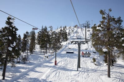
Ski lessons in Warth-Schröcken
Book now

Warth-Schröcken Weather (Next 3 days): The snow forecast for Warth-Schröcken is: Moderate rain (total 16.0mm) heaviest on Thu afternoon, then becoming colder with a dusting of snow on Thu night. Very mild (max 10°C on Thu afternoon, min 1°C on Thu night). Wind will be generally light.
Warth-Schröcken Weather (Days 4-6): Heavy rain (total 42.0mm), mainly falling Mon night. Becoming colder with a light covering of snow, mostly falling on Tue night. Very mild (max 10°C on Sun afternoon, min 1°C on Tue night). Wind will be generally light.
| Resort | Snow Depth | Temp. (°C) | Wind (km/h) | Weather | ||
|---|---|---|---|---|---|---|
| Top Lift: | 6 | |||||
| Middle Lift: | 10 | |||||
| Bottom Lift: | 13 |
Latest snow reports near Warth-Schröcken:

Thu 2 | Friday 3 | Saturday 4 | Sunday 5 | Monday 6 | Tuesday 7 | Wednesday 8 | ||||||||||||||
PM | night | AM | PM | night | AM | PM | night | AM | PM | night | AM | PM | night | AM | PM | night | AM | PM | night | |
risk thun- der | light snow | light snow | light rain | light snow | some clouds | light rain | rain shwrs | light rain | light rain | rain shwrs | some clouds | light rain | heavy rain | light snow | light rain | mod. snow | light snow | light rain | light rain | |
km/h | ||||||||||||||||||||
Snow map |  |  |  |  |  |  |  | |||||||||||||
— | 1.0 | 1.0 | — | — | — | — | — | — | — | — | — | — | — | 2.0 | — | 5 | — | — | — | |
6 | 4 | — | 2.0 | 1.0 | — | 1.0 | 1.0 | 1.0 | 3 | 4 | — | 3 | 23 | 3 | 5 | — | 1.0 | 2.0 | 2.0 | |
max°C | 10 | 5 | 2 | 3 | 2 | 6 | 8 | 7 | 8 | 10 | 8 | 10 | 10 | 4 | 2 | 3 | 2 | 2 | 5 | 4 |
min°C | 9 | 1 | 1 | 3 | 1 | 2 | 7 | 5 | 5 | 9 | 6 | 7 | 8 | 2 | 2 | 3 | 1 | 2 | 4 | 3 |
9 | -1 | -1 | 2 | 1 | 1 | 7 | 5 | 5 | 9 | 5 | 6 | 7 | 0 | 2 | 1 | 1 | 2 | 3 | 3 | |
69 | 99 | 99 | 94 | 99 | 69 | 74 | 82 | 64 | 75 | 85 | 62 | 95 | 99 | 99 | 99 | 98 | 99 | 93 | 87 | |
2800 | 1900 | 1950 | 2100 | 1950 | 2500 | 2700 | 2550 | 2700 | 2850 | 2850 | 2750 | 2900 | 2250 | 2050 | 2100 | 1950 | 2100 | 2350 | 2700 | |
— | — | 5:58 | — | — | 5:56 | — | — | 5:56 | — | — | 5:54 | — | — | 5:52 | — | — | 5:52 | — | — | |
— | 8:31 | — | — | 8:32 | — | — | 8:35 | — | — | 8:36 | — | — | 8:37 | — | — | 8:38 | — | — | 8:39 | |
Moderate rain (total 16.0mm) heaviest on Thu afternoon, then becoming colder with a dusting of snow on Thu night. Very mild (max 10°C on Thu afternoon, min 1°C on Thu night). Wind will be generally light.
Heavy rain (total 42.0mm), mainly falling Mon night. Becoming colder with a light covering of snow, mostly falling on Tue night. Very mild (max 10°C on Sun afternoon, min 1°C on Tue night). Wind will be generally light.
Latest snow reports near Warth-Schröcken:
| Top snow depth: | — |
|---|---|
| Bottom snow depth: | — |
| Fresh snowfall depth: | — |
| Last snowfall: | 24 Apr 2024 |
| Snow Alerts | Create Alert |
0.0 | Bluebird Powder days Fresh snow, mostly sunny, light wind. |
|---|---|
0.4 | Powder days Fresh snow, limited sun, any wind. |
0.0 | Bluebird days Average snow, mostly sunny, light wind. |


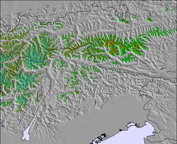
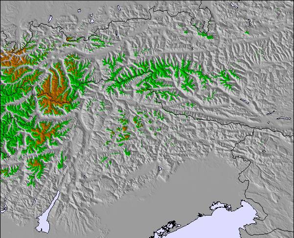
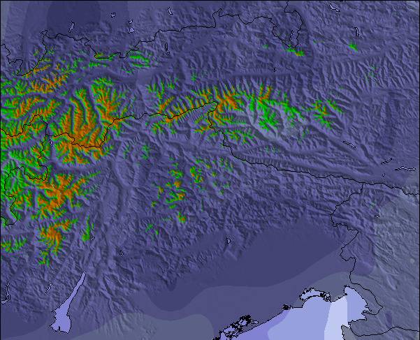
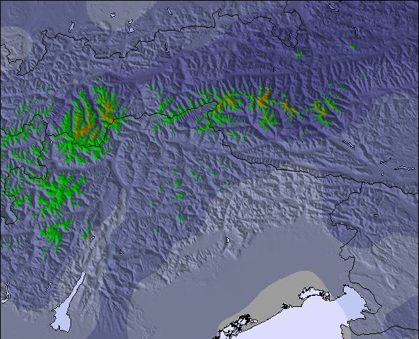
The above table gives the weather forecast for Warth-Schröcken at the specific elevation of 1662 m. Our sophisticated weather models allow us to provide snow forecasts for the top, middle and bottom ski stations of Warth-Schröcken. To access the weather forecasts for the other elevations, use the tab navigation above the table. For a wider view of the weather, check out the Weather Map of Austria.
Click here to read further information on freezing levels and how we forecast our temperatures.
Resort name is also written as Warth-Schroecken.
Overall 3.5 Based on 6 votes and 1 review
My wife and I originally skied in Warth-Schröcken in March 2014 when we made the trek across from St Christoph a couple of times. We liked the resort and the runs so decided to spend a full week there this January. Although the skiing, in Warth, is rather limited, there’s enough to keep a competent intermediate happy for a couple of days. The black runs (W1, W2 and W8) from the Saloberkopf are pretty easy and within the scope of most intermediates. The resort is not great for beginners though. The red run down to Warth is quite steep, and the only nursery slopes, low down, are adjacent to the village on either side of the road. However, the newly constructed blue run (W23) offers an easier, if narrow alternative route back to Warth village. There’s also a new narrow but pleasant red ski route down to Schöcken which is regularly pisted. There’s no lift back but there are frequent buses to the Hochtannberg Pass and Warth. The great advantage of Warth is the Auenfeldjet connection to Lech. This takes about 15 minutes to its end, though on the return journey you can ski to the bottom Auenfeldjet station and get back to connecting lifts in about 9 minutes. Accommodation and restaurant prices, in Warth, are much cheaper than in Lech so it provides a low cost alternative for the budget conscious. It’s possible to ski from Lech to Zürs on the Weisse Ring route. The only way to ski back to Lech, however, is to use ski route 33 to Zug and either complete the Weisse Ring or use ski route 56 back to Lech (not open when we were there). There are buses which plough between Lech and Alpe Rauz (the link to St Anton and Stuben) but we found them such a bun fight the previous year that we didn’t bother this time. A better alternative, if there are four or more of you, is to use the VW taxis which are quite cheap. If you’ve got transport and want to ski elsewhere, the Drei Täler pass covers Damuls (45 minute drive) and several other small resorts in the Bregenzerwald If you’re after lively après-ski, then don’t go to Warth. Apart from a couple of igloos next to the pistes which filled up during happy hour with Germans singing drinking songs, there’s not much going on. There are about half a dozen restaurants and cafes which provide the usual Austrian fare. If you’re self catering, bring as much as you can with you, as the solitary Spar does not have a great choice of food. In summary, quiet resort with a good snow record which is fairly cheap and has access to a large ski area.
Howard Beanland from United Kingdom writes:
My wife and I originally skied in Warth-Schröcken in March 2014 when we made the trek across from St Christoph a couple of times. We liked the resort and the runs so decided to spend a full week there this January. Although the skiing, in Warth, is rather limited, there’s enough to keep a competent intermediate happy for a couple of days. The black runs (W1, W2 and W8) from the Saloberkopf are pretty easy and within the scope of most intermediates. The resort is not great for beginners though. The red run down to Warth is quite steep, and the only nursery slopes, low down, are adjacent to the village on either side of the road. However, the newly constructed blue run (W23) offers an easier, if narrow alternative route back to Warth village. There’s also a new narrow but pleasant red ski route down to Schöcken which is regularly pisted. There’s no lift back but there are frequent buses to the Hochtannberg Pass and Warth.
The great advantage of Warth is the Auenfeldjet connection to Lech. This takes about 15 minutes to its end, though on the return journey you can ski to the bottom Auenfeldjet station and get back to connecting lifts in about 9 minutes. Accommodation and restaurant prices, in Warth, are much cheaper than in Lech so it provides a low cost alternative for the budget conscious. It’s possible to ski from Lech to Zürs on the Weisse Ring route. The only way to ski back to Lech, however, is to use ski route 33 to Zug and either complete the Weisse Ring or use ski route 56 back to Lech (not open when we were there). There are buses which plough between Lech and Alpe Rauz (the link to St Anton and Stuben) but we found them such a bun fight the previous year that we didn’t bother this time. A better alternative, if there are four or more of you, is to use the VW taxis which are quite cheap.
If you’ve got transport and want to ski elsewhere, the Drei Täler pass covers Damuls (45 minute drive) and several other small resorts in the Bregenzerwald
If you’re after lively après-ski, then don’t go to Warth. Apart from a couple of igloos next to the pistes which filled up during happy hour with Germans singing drinking songs, there’s not much going on. There are about half a dozen restaurants and cafes which provide the usual Austrian fare. If you’re self catering, bring as much as you can with you, as the solitary Spar does not have a great choice of food.
In summary, quiet resort with a good snow record which is fairly cheap and has access to a large ski area.
The Warth-Schröcken skiing weather widget is available to embed on external websites free of charge. It provides a daily summary of our Warth-Schröcken snow forecast and current weather conditions. Simply go to the feed configuration page and follow the 3 simple steps to grab the custom html code snippet and paste it into your own site. You can choose the snow forecast elevation (summit, mid-mountain or bottom lift) and metric/imperial units for the snow forecast feed to suit your own website…. Click here to get the code.
View detailed snow forecast for Warth-Schröcken at:
snow-forecast.com


 Nearest