World Snow Roundup #231
(Updated 28th February 2024) A comprehensive review of snow conditions, weather, and updates for Europe, North America and Asia's winter sports destinations.

Issued: 28th February 2024
By Patrick “Snowhunter” Thorne
World Overview
The focus of world snowfall has finally switched to the Alps for the first time in 2024 as temperatures dropped, the heavens opened and there was the long-awaited heavy snowfall. Some centres posted 60cm (2 feet) in 24 hours, others as much as a metre (40″) on higher slopes through the weekend. The weather caused the usual temporary access issues and some centres delayed opening to dig out and make slopes safe, although, of course, as freeriding possibilities return, the avalanche danger increases. More snowfall is underway as we publish this week’s report.
The snowfall in Europe was not just in the Alps though. The Pyrenees saw one of their best snowfalls of 2024, albeit having been one of the worst snowfall seasons there on record, so this was just a minor respite in the snow drought. The snow also kept falling in Scandinavia, there was a little in Eastern Europe and also improving conditions in Scotland.
Not so much snowfall in North America this week but most areas have seen some snow. The fresh snow in Alberta and BC was particularly welcome, while the worldwide ski racing TV audience could see the excellent conditions in California after witnessing the often poor conditions on lower slopes in the Alps over the past few months. Ironically heavy snowfall and resulting great powder conditions led to the cancellation of the corresponding women’s Alpine skiing downhill races planned for Val di Fassa in the Italian Dolomites at the weekend.
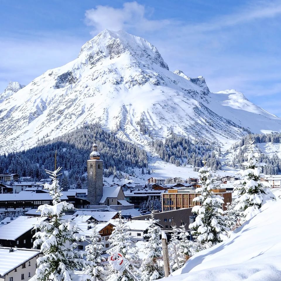
Europe
EUROPE INTRO
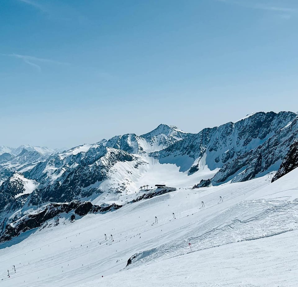
The forecast snowfall did start to arrive in the Alps last weekend with some good accumulations on Friday morning. Resorts reported up to 90cm (three feet) of snowfall in the first 24 hours, although more widely 10-30cm (4-12”), with the biggest falls reported in Switzerland. The snow was falling over a wider area though with fresh snowfall in the Pyrenees too and by Monday it was Austrian areas posting the biggest snow totals, with several posting over 1 metre (40″) had landed. The greatest volumes were of course up high but the snowfall continued down to low elevations where it was needed most. Due to all the snowfall the avalanche danger has, unsurprisingly, risen in many areas from the relatively low level 1 or 2 on the scale to 5 it has been at for much of this year to at least level 3 (“considerable”) – generally regarded as the most dangerous on the scale as it’s the one where people think they can still “risk it” with the excitement of the enticing fresh powder – sadly sometimes with bad consequences. More heavy snowfall has begun again in the alps as we publish this week’s report.
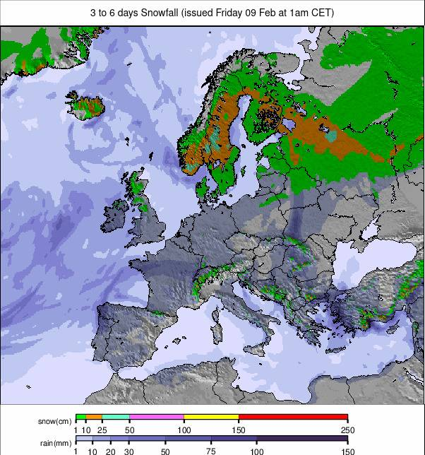
Image: European snowfall summary overview for the next 3-6 days.
AUSTRIA REPORT
Austrian ski centres posted some of the biggest snowfalls in the world over last weekend. The country’s glaciers performed particularly well with the Stubai (70/380cm / 28/152”) reporting 80cm (32”) in 48 hours, the most of any area. The Kitzsteinhorn (70/325cm / 28/130”) posted 70cm (28”) of snowfall and Solden (20/343cm / 8/137”) 50cm (20”). But there was snowfall down to lower elevations too with Bad Kleinkirchheim (50/130cm / 20/52”) among those posting 45cm (18”) over the weekend. With Austrian centres due to start closing at the end of the month and valley temperatures still getting up to +10C in the afternoons, the new snow is a great refresh for the slopes. Glaciers staying open into May or later also have heavy healthy bases now to (hopefully) see them through late spring.
AUSTRIA FORECAST
Continuing colder than it has been for much of winter as we enter springtime in Austria. Temperatures are down to +5C in the afternoons in most Austrian Alpine Valleys and dropping below freezing overnight. Plenty of sunshine but also some light snow showers expected through the rest of this week.
SWITZERLAND REPORT
Swiss ski centres posted the biggest accumulations at the start of the weekend snowstorms. Arolla (20/200cm / 8/80”) reported a remarkable 95cm (38”) snowfall on its higher slopes on Friday morning, by far the most in Switzerland, Europe or the world. Glacier 3000 (15/309cm / 6/123”) claimed the second biggest snowfall in Switzerland/Europe/The world over the same period with a 60cm (two feet) accumulation and delayed opening that morning to allow staff to make slopes safe and dig out lifts. There were 20-50cm (8-20”) falls across the rest of the country’s slopes and for many, particularly in the south and west of the country, it has kept snowing ever since! Laax (5/380cm / 2/152”) continues to post Switzerland’s deepest snow up top and the 4 Valleys around Verbier (22/258cm / 9/103”) the most skiable terrain with 95% of its 410km (257 miles) of slopes still open.
SWITZERLAND FORECAST
Continuing colder than it has been recently with the freezing point between 500 and 1900m. Calmer conditions now with plenty of sunshine but still with the occasional light snowfall.
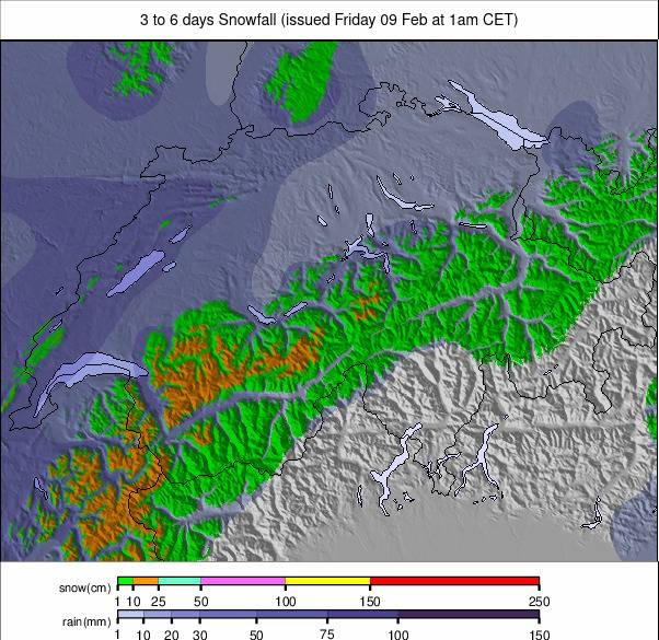
Image: Switzerland snowfall forecast for the next 3-6 days.
FRANCE REPORT
French resorts had some great snowfalls at the end of last week and into the weekend, the biggest of 2024 to date. Les Menuires (20/160cm / 8/64″) posted a 75cm (30″) snowfall on its higher slopes on Friday/Saturday, one of the biggest in the Alps. It helped the 3 Valleys maintain its ‘most open in the world’ with more than 550km (2%) of its slopes open, just ahead of the Portes du Soleil (15/155cm / 6/62″) which are at 90% open and 520km (175 miles) of runs. Meanwhile, Alpe d’Huez ( 103/480cm / 41/192”), which had been the only centre in the world still posting a 4m+ (160”+) base has seen it jump closest to a 5m (200”) base of any centre so far. Light snow showers have continued in many areas since the big weekend falls, interspersed with sunny spells, bringing 5-10cm (2-4”) accumulations most days.
FRANCE FORECAST
It’s looking likely to be a little warmer and drier than it has been over the next few days, with afternoon highs in low valleys getting up towards double figures and the freezing point up at 2000m around the same time, but another wave of snowfall with lower temps should end the week.
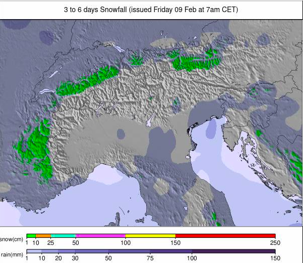
Image: European Alps snowfall forecast for the next 3-6 days.
ITALY REPORT
Italy has transformed to winter mode over the past four or five days with the biggest snowfalls of 2024 recorded for most slopes across the country. The heaviest snowfall came at the weekend for most areas, but it has kept snowing on and off since. Sella Nevea (25/280cm / 10/112”) over on the Slovenian border saw one of the biggest reported falls – 68cm (17”) in 24 hours on Friday/Saturday. But quite a few more areas posted at least 60cm (24”) in the same period. Trentino also scored highly with Folgàrida – Marilléva (50/135cm / 20/54”) posting 75cm (30”) of fresh snowfall in 48 hours, Madonna di Campiglio slightly less. Most of Italy’s big ski areas are 100% open.
ITALY FORECAST
More heavy snowfall is expected in Trentino and the south and east of Italy into midweek, with lighter showers further north and west, but then drier, sunny weather for the latter half of the week before more snowfall is expected to end the week and start next. Temperatures are cooler than they’ve been, the freezing point typically between 700 and 1700m.
GERMANY REPORT
Germany saw some good snowfalls at the end of last week with the country’s highest slopes at Zugspitze (258/262cm / 103/105”) posting a 40cm (16”) accumulation and most of the country’s other bigger resorts getting 10-20cm (4-8”) at the same time. That was about it though and it didn’t make a lot of difference to the fact that the current snowpack across Germany is averaging about 20% of the multi-year average, and 75% of the country’s ski areas (the smaller, lower 75%), remain closed. After the cold, snowy end of last week, there’s been plenty of sunshine with temperatures back up to +10C in valleys.
GERMANY FORECAST
A largely dry remainder of this week and the start of next. Cooler than it has been, the freezing point moving between around 500m and 1990m through each day and the week. A mixture of sunny and overcast conditions with just the occasional very light snow shower.
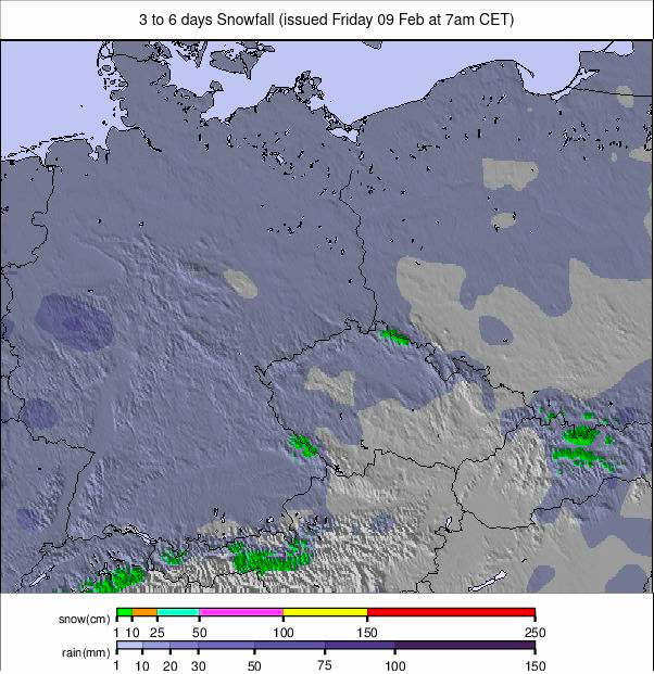
Image: Germany snowfall forecast for the next 3-6 days.
SCANDINAVIA REPORT
Scandinavia continues to see excellent conditions with temperatures generally remaining just below freezing and daylight hours stretching away now. There’s been more fresh snowfall across the region too. The big news of this week is Riksgransen (80/160cm / 32/64″) opening for its 2024 season at the weekend., It plans to offer skiing under the midnight sun when 24-hour daylight returns in May, as usual, and to reopen for snowsports at midsummer in June, an offering that has been hit and miss in recent years. Meanwhile Are (60/113cm / 24/45”) continues to post the most terrain open in the region, with 90% of its slopes currently accessible, Norway’s Myrkdalen (140/240cm / 46/96”) continues to post the deepest snow in the region, up 40cm (16”) on 7 days ago.
SCANDINAVIA FORECAST
There are some big snowfalls, potentially the biggest in Europe this week, forecast for the last three or four days of this week. Temperatures will be warmer than they have been, up to -5 to +3C, but up to 60cm (two feet) of snowfall is expected within 72 hours.
SCOTLAND REPORT
It’s been a week of progress for Scottish ski centres which went from almost nothing open beyond a few nursery slope areas a week ago to more consistently cold temperatures and snowfall on the upper mountain improving things. Glencoe (20/40cm / 8/16”) has had the biggest improvement, going from fully closed bar the dry slope nursery slopes to re-opening for top-to-bottom skiing on its full vertical and about half of its runs open. Elsewhere Glenshee has three runs open, Cairngorm and the Lecht still had only all-weather snowmaking served nursery slop[e areas operating and Nevis range is currently closed for skiing and boarding.
SCOTLAND FORECAST
The forecast is looking relatively promising – especially for higher slopes, with plenty of precipitation and overnight low/higher terrain remaining around freezing or just below. Valley highs up towards +6 or +8C so not so good for lower terrain.
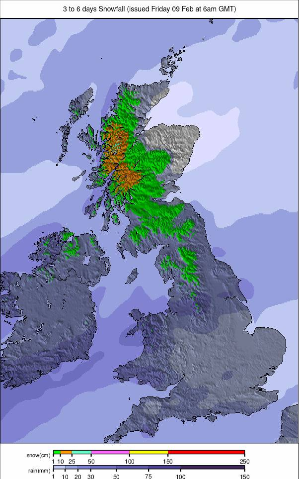
Image: UK and Northern Ireland snowfall forecast for the next 3 – 6 days.
SPAIN / ANDORRA REPORT
There was some rare (this season) fresh snowfall in the Pyrenees at the weekend with Spain’s largest area, Baqueira Beret (65/95cm / 26/38”), excitedly reporting “powder” conditions after a 5-10cxm (2-4”) accumulation on Friday. Similar falls were reported elsewhere but have not really made a massive impact on the amount of terrain open, with the region’s snowpack still less than 15% of its average for this point in the season, the big areas mostly 30-60% open, some smaller, lower altitude areas still struggling to open much at all and giving up on the 23-24 season now. Andorra’s Grandvalira (30/60cm / 12/24”) continues to post the most area open, with about half of its 240km (150 miles) of runs.
SPAIN / ANDORRA FORECAST
The snowfall will ease off midweek and sunshine will be back for the remainder of the week. The freezing point will be lower through with some of the coolest temperatures we’ve seen this year and a chance of more snowfall this weekend.
BULGARIA / ROMANIA REPORT
Conditions remain mixed in Bulgaria and Romania, with plenty of sunshine and some warm temperatures again this week, but also some snow showers bringing a few centimetres of fresh snowfall to high slopes. Centres remain 60-80% open with upper runs complete, valley runs maintained at most areas, but with no snow at resort level. Bansko (10/90cm / 4/36”) has seen its upper slope base depth drop below the metre mark but still has more than 80% of its slopes open, the most in the region, with 64km (40 miles) of runs, including the 16km (10 miles) long run back down to resort from the main ski area.
BULGARIA / ROMANIA FORECAST
A mostly sunny first week of spring with temperatures reaching +12C in afternoons in valleys, but it’s due to get colder with more light snowfall up high and temperatures down to freezing even at low elevations.
CZECH REPUBLIC / SLOVAKIA REPORT
There was snowfall in Northeastern European countries including Czechia, the Slovak Republic and Poland to end last week, but most centres have seen clear skies, with a mixture of sunshine and cloud, since. The snowfall did not make a huge difference to the big picture, which remains decent snow cover at bigger centres on higher slopes, with low altitude, smaller areas struggling to open much at all, as has been the picture all winter. The Czech Republic’s largest area Špindlerův Mlýn (40/100cm / 16/40”) has closed a few runs but remains 95% open, in Slovakia, the region’s biggest centre Jasna (40/100cm / 16/40”) has dropped to 85% open.
CZECH REPUBLIC / SLOVAKIA FORECAST
Remaining dry for the rest of this week with temperatures reaching +10C in valleys, so the spring thaw is likely to take a great hold on lower slopes. Above freezing even on high slopes but overnight lows are still down to -1 or -2.
NORTH AMERICA
NORTH AMERICA INTRO
A quieter week in North America but there has been some fresh snowfall from, coast to coast with temperatures remaining cool, if not cold – other than up in Quebec in the Northeast before the weekend – too. Most of the snowfall over the last seven days have been counted in inches, rather than feet, and we’ve seen snowfall in the Rockies, New England and California. North of the border there were some good weekend snowfalls in Alberta and Eastern BC with resorts reporting up to 25cm (10″) in 24 hours, the biggest accumulations of the past month or so.
ROCKIES REPORT
The Rockies have had a snowier week than forecast keeping conditions fresh across the region with plenty of powder to play in. Utah is posting the best stats in North American skiing right now with the country’s largest ski area at Park City (76/132″/ 191/329cm) 100% open and posting one of the thickest snowpacks in the US. It’s topped though by fellow Utah area Alta (64/151″ / 160/378cm) which has the deepest snowpack in North America. Some areas have reported up to a foot (30cm) more snowfall over the past few days.
ROCKIES FORECAST
After the recent snowfall, the weather is likely to remain sunny in most resorts over the rest of this week, although it’s looking more unsettled towards the weekend. Temperatures reaching the low 40s in the afternoons at resort level, down to high teens overnight on mountain.
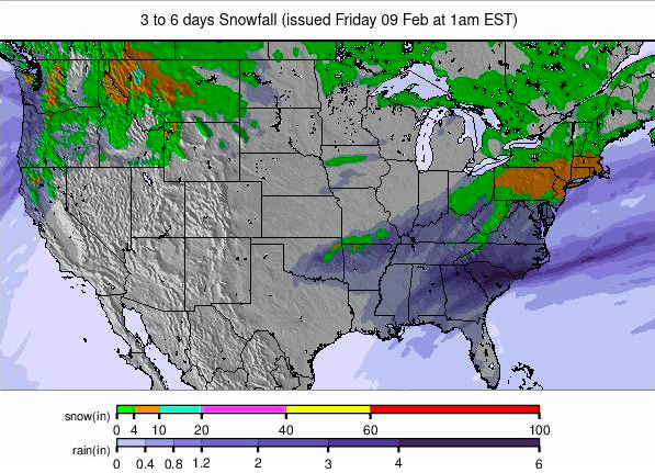
Image: USA summary overview snowfall forecast for the next 3-6 days.
USA WEST REPORT
The news from the US West is that February’s snowstorms have doubled the snowpack there and conditions are excellent now in California. Mammoth Mountain (97/142” / 244/356cm) is posting the second deepest snowpack in North America, totally transformed after the snowless start of the season in November/December. The Men’s World Cup Alpine Skiing tour crossed back over the Atlantic for GS and Slalom races at Palisades Tahoe (50/120” / 125/300cm) with viewers seeing beautiful snow conditions and sunny skies. It has joined the select group of US areas that have reached a 10-foot upper slope base. Most ski areas in the region are at least 80% open now but up in the north, ski areas are still struggling with Crystal Mountain (22/32″ / 55/80cm) still only 62% open.
USA WEST FORECAST
Temperatures staying low, mostly below freezing, and after sunny weather midweek some potentially very heavy snowfall is expected to end the week and start March.
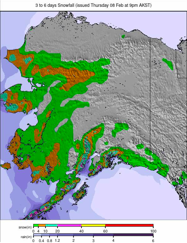
Image: Alaska snowfall report for the next 3-6 days.
MIDWEST REPORT
A mostly dry, mostly sunny week across the Midwest, although with some light snowfall reported in more northerly parts of states like Michigan. Temperatures have mostly been below freezing but there have been some trips up into the 40sF and for centres already struggling with thin cover it increasingly feels like the end of the season is nigh, with the start of spring just around the corner now. Ski Brule (48/56” / 120/140cm) continues to post the deepest snow in the area and remains 100% open.
MIDWEST FORECAST
Sunny and warm in some states like Wisconsin with daytime highs in the 50s looks bad news for the remaining snow. Not that warm, and with some midweek snowfall forecast for states like Michigan, but still due to get well into the high 40s.
USA EAST REPORT
It has been mostly dry and sunny weather across the Eastern US over the last week. Temperatures have been below freezing, much of the time, just creeping up to the low 40s some afternoons. There have been a few light snow showers bringing just an inch or two of snowfall too, but generally, conditions are among the best they’ve been all season at present. Vermont’s Killington (8/18″ / 20/45cm) continues to post a thin base but reports 90% of its slopes open, the most in the East. Snowshoe Mountain (45/115cm / 18/46″) down in West Virginia, which is 100% open, is posting the region’s thickest snowpack.
USA EAST FORECAST
Unfortunately, there’s some warm weather forecast for the remainder of this week, with valley temperatures getting into the high 40s with warm sunshine too, not good news for the lower snowpack.
CANADA
CANADA WEST REPORT
There has been more snowfall, particularly for higher slopes across western Canada and most of the big ski areas of Alberta and BC are fully open. Unfortunately, though, smaller centres, particularly towards the Pacific Coast in BC, continue to suffer. This week Shames Mountain up near Terrace on the Alaskan border said it would offer free skiing to season pass holders from other smaller resorts like Murray Ridge, Troll, Purden and Mount Timothy which are currently closed due to inadequate snow cover and there’s unfortunately no real sign of an imminent improvement. Of the big names though Whistler (0/153cm / 0/61″) is 80% open, and Sun Peaks (41/145cm / 16/58″) is 100% open. Ski areas in Western BC and Alberta celebrated some decent snowfalls at the weekend, adding 20-35cm (8-10”) of new snow, some of the biggest falls of recent weeks.
CANADA WEST FORECAST
Colder temperatures than we’ve seen recently and some decent snowfall is expected for the latter half of this week.
CANADA EAST REPORT
Conditions have remained good across much of eastern Canada over the last seven days. There’s not a huge amount of fresh snowfall to report, just a few showers, but temperatures have mostly been in the -5 to -20C range, keeping the snow in good shape, just occasionally creeping above freezing in the afternoons at low levels. Mont Tremblant (0/140cm / 0/56”) is posting the region’s deepest snow and the most open terrain, with 92% of its slopes open. Further east, the region’s second biggest report Mont-Sainte-Anne (50/70cm / 20/28”) has about 85% of its slopes open.
CANADA EAST FORECAST
Unfortunately, there are some warm temperatures in the mix for the rest of this week with daytime highs around +10C likely to impact snow conditions. Freeze thaw though with temperatures still expected to get below freezing overnight.
ASIA
JAPAN REPORT
A quieter week on Japanese slopes with no big snowfalls to report, temperatures a little warm and a good deal of dry weather with just occasional snow showers. Tengendai Kogen Ski Area (100/330cm / 40/132”) in Yamagata is posting the deepest snow in the country but only just ahead of Niseko (110/310cm / 44/124”) which posted 20cm (8”) of fresh snowfall over the weekend.
JAPAN FORECAST
Overcast skies in northern Japan, sunnier further south, temperatures in the -15 to +5C range. There’s snowfall forecast in most areas, most likely to be heaviest on Hokkaido, but nothing huge – 5-0cm (2-4”) accumulations, and similar expected further south in areas like Hakuba and Nagano.
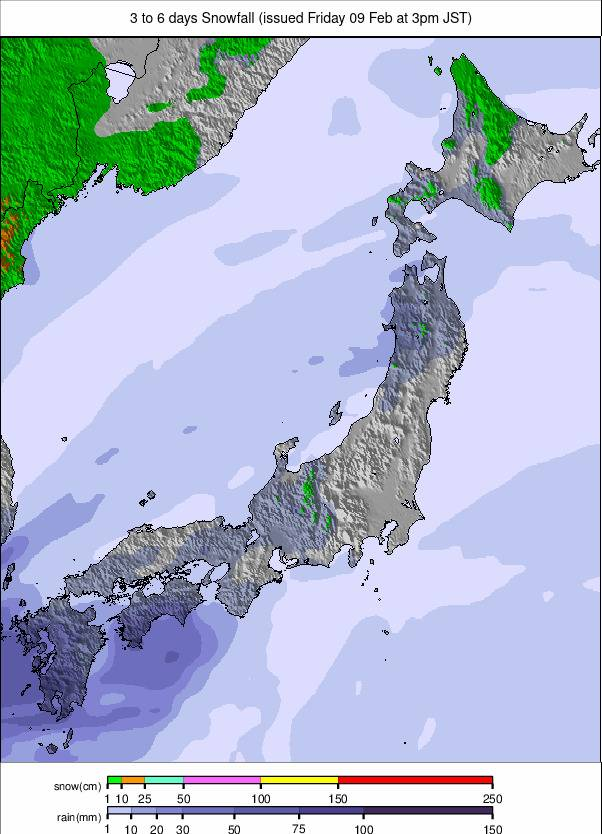
Image: Japan snowfall forecast for the next 3-6 days.