WORLD SNOW ROUNDUP #227
Issued: 31st January 2024
By Patrick “Snowhunter” Thorne
World Overview
Skiers in much of Europe could be forgiven for thinking we’re approaching the start of April, not the start of February, with high pressure dominating and bringing sunny weather and warmer temperatures; much too warm for late January with the freezing point climbing above 3,000m in most regions. Thankfully, the large amount of early winter snowfall means that the snow is lying deep enough to withstand this and slopes remain open in most areas, with conditions remaining good for runs above 2,000m. However, there is a battle to keep runs lower down open, and the more southerly and low-lying centres are facing the greatest challenges.
Meanwhile, in North America, things are finally progressing in a more positive direction as the very poor start to the season was finally relieved by a relatively optimistic January, with some areas in the west clocking up over six feet (q1.8m) of snowfall through the month. Most areas are at least 70% open, and some have reached 100%. There has been more improvement in the east too, with more consistent cold temperatures finally allowing bases to build (albeit with the odd blip).
In Asia snowfall has finally arrived in the Indian Himalayas after the terrible season start there and in Japan regular snow deliveries are arriving in Hokkaido, a little more sporadic in Honshu, although most centres there are now fully open too.
Europe
EUROPE INTRO
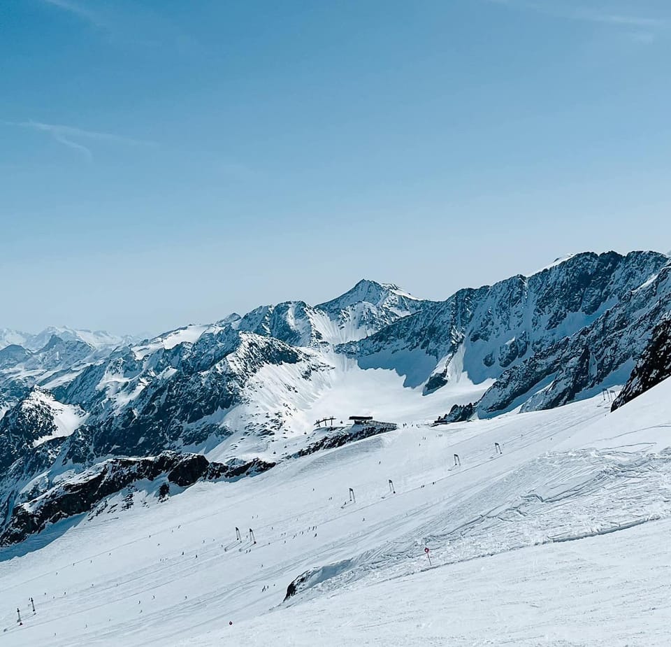
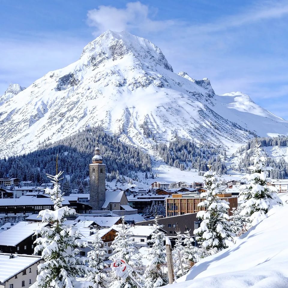
It has been a mostly dry week across Europe. Strong winds have been an issue again on high slopes, but the bigger problem has been warm weather, with temperatures regularly hitting +10C in valleys and getting well above freezing in the afternoons on the high slopes as well. Despite this, there’s little change to reported snow depths or open terrain, both down slightly, but only due to minor issues like being 96-94% open or snow depths of 4.1-4.2m, so nothing major to worry about in the big resort. The issues are below 2,000m altitude where the snow is thinner, thawing faster and getting wet quicker each day. Outside the Alps, in the Pyrenees and across southern European mountains, it’s a similar but worse situation. Although some snowfall has been reported on higher slopes In Slovenia, Bulgaria and the Balkans. Scandinavia continues to report the best snow conditions, with all slopes open, but Scotland has suffered from more than a week of gales and warm weather with most slopes closed as a result.
AUSTRIA REPORT
January is ending dry and sunny in Austria, with temperatures a little too warm for comfort over the last week in valleys but with fresh snowfall reported on higher slopes. The worst of the warm weather came a week ago when ski areas reported heavy snowfall below about 1500m, but at the same time centres got 20-40cm (8-16″) of snowfall higher up. Since then it has been mostly dry with plenty of sunshine, but with temperatures reaching as high as +10C in Austrian valleys. There’s little change in snow depth nor terrain open compared to a week ago. The Arlberg around St Anton (65/360cm / 26/144”) continues to post the most terrain open (280km / 175 miles / 90% of its area) and the deepest snowpack.
AUSTRIA FORECAST
Similar conditions are forecast for the first week of February, although with more cloud and some light snowfall expected in the west of the country to end the week before sunshine returns for the weekend.
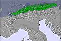
Image: European Alps snow forecast for the next 3 days.
SWITZERLAND REPORT
The weather has settled down across much of Switzerland and we’re seeing plenty of sunny, rather mild weather. Temperatures reaching +10C at 1,000m altitude in the afternoons, freezing point up around about 2,000m. Most of the country’s slopes remain in good shape but lower runs are obviously impacted by thawing and periods of rain, so definitely better higher up. Laax (20-/365cm / 8/146”) is both posting the deepest snowpack in the country and graphically illustrating the difference between valley and altitude/glacier snow levels. The 4 Valleys (40/250cm / 16/100”) continue to post the most open terrain in the country at 390km (243 miles) of runs, which is more than 95% of the full area.
SWITZERLAND FORECAST
High pressure remains largely in control for the rest of this week with plenty more sunshine in the forecast, but not much precipitation other than light showers in the east over the next few days. Freezing point averaging around 2,000m.
FRANCE REPORT
It has been a mostly dry week with plenty of sunshine in the French Alps. Temperatures have been warm, with the freezing point climbing above 2000m and valley temperatures as high as +10C. This has led to the cancellation of downhill ski races planned this weekend at Les Houches in the Chamonix Valley. However, France still has the world’s deepest snowpack and most remain slopes open. Even these temperatures will take months to cause disruption. The 3 Valleys (150/21cm / 60/84”) remain 95% open with over 550km of slopes available to enjoy. Lastly, bases have dropped slightly but three areas are still posting 4m (13.3’), plus bases led by Les Arcs (60/420cm / 24/168”).
FRANCE FORECAST
A sunny week ahead with warm temperatures bringing more springlike conditions and thawing on lower slopes. Valley highs will be up to + 11C at 1,000m altitude and the freezing point will be up above 3,000m at times. The best snow conditions are still up high.
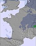
Image: France snow forecast for the next 3 days.
ITALY REPORT
Italy has faced the same issue of warm daytime temperatures as most of the rest of Europe over the past week, with rain reported for some areas on lower slopes on Wednesday, but it has been cold with some snowfall beforehand. Since then, the conditions have been mostly sunny with valley temperatures as high as +10C in the afternoon. While the return of colder, snowier weather would be welcome there’s not been much damage done as yet, with most centres still fully open. Val Gardena (50/70cm / 20/28”), for example, continues to have almost every run open and every lift turning. The Milky Way (Via Lattea) around Sestriere and Sauze d’Oulx (165/215cm / 66/86”), which had been struggling to get more than half of its 400km (250 miles) of runs open (the largest solely in Italy when fully open), has also hit a season-high of 280km (175 miles).
ITALY FORECAST
Warm, dry and mostly sunny weather is forecast across Italy for the next seven days. Temperatures reaching +10C at 1,000m altitude and the freezing point climbing above 3,000m in the afternoons.
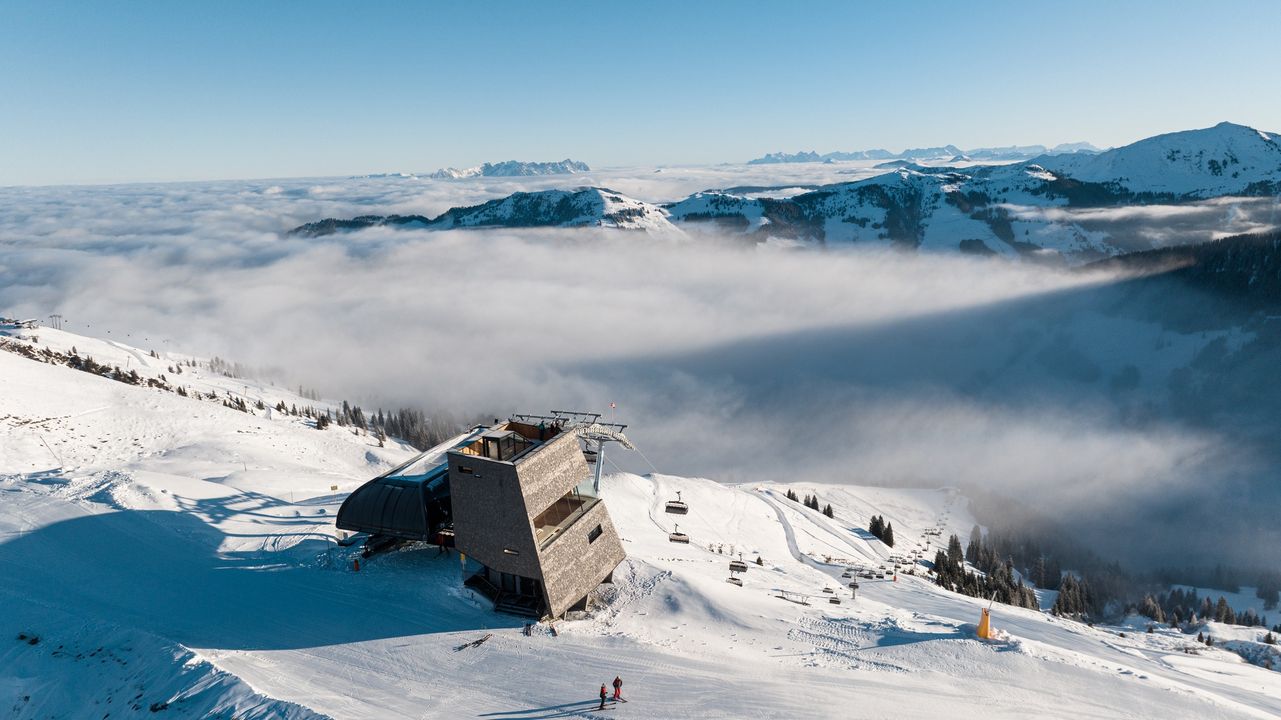
GERMANY REPORT
Most smaller, lower German ski areas remain closed after some of the best snowfalls in over a decade in late December were followed by some of the warmest temperatures, meaning most of the gains were lost. January has seen little fresh snow and too mild temperatures down low for any respite, but higher runs are looking better. Garmisch illustrated the issues when it was the world focus for ski racing last weekend but looked more like end-of-season April/May snow than January. More races planned there this coming weekend have been cancelled as things continue to deteriorate. Balderschwang (60/80cm / 24/32”) continues to post the most terrain open in the country, all 41km (26 miles), 100% of its area. The Zugspize (120/250cm / 48/100”) maintains its almost constant status as having the deepest snow as a result of having the country’s highest slopes.
GERMANY FORECAST
The conditions in the week ahead show things more unsettled in Germany than further south, with 10-20cm (4-8″) of snowfall expected on higher slopes Thursday/Friday. However, the bigger picture is again one of warm temperatures most days to high elevations, so any gains will be short-lived and there may be rain on lower slopes.
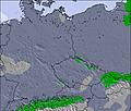
Image: Germany snow forecast for the next 3 days.
SCANDINAVIA REPORT
Another generally good weather report from Scandinavian ski areas. We have not seen many big snowfalls yet and there have been strong winds causing operational problems, but while most other parts of Europe have been too warm, the last week has seen temperatures typically in the -5 to -20C range across Finland, Norway and Sweden’s ski slopes, so continuing good snow conditions reign across Scandinavia. The famous powder resort of Myrkdalen (150/200cm / 60/80”), near Voss, in Norway is reporting the deepest snow in the region and Are (50/100cm / 20/40”), in Sweden, reports the most open terrain, 90% of its 90km (56 miles) of slopes.
SCANDINAVIA FORECAST
It appears that more southerly areas in the region will suffer the brunt of the warm weather impacting Europe over the next few days, with possible highs of +7 and +8C in some valleys, but temperatures should drop away and be more consistently back below freezing by the weekend. Again, a mixed forecast of light snow showers, overcast and sunny days for the week ahead.
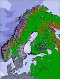
Image: Scandinavia snow forecast for the next 3 days.
SCOTLAND REPORT
It’s been a real roller coaster of a week for the Scottish mountains, with three separate periods of violent gales interspersed with windy weather, and then some torrential rain and thawing temperatures thrown into the mix. Unsurprisingly, we’ve therefore gone from everywhere having something open to only a few centres left with parts open; although it has become colder again in the past few days and higher mountain areas saw heavy snowfall when it rained down below. Cairngorm, Glencoe and Glenshee still have some terrain open, but The Lecht really just has its nursery slope open at present.
SCOTLAND FORECAST
Sadly, there’s little sign of any improvement on Scottish slopes over the coming week. Instead, temperatures are rising, more gales are set to sweep in and it’s rain rather than snow forecast at most elevations.
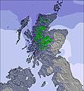
Image: Scotland snow forecast for the next 3 days.
SPAIN / ANDORRA REPORT
Unfortunately, the battle to keep ski areas even partially running in the Pyrenees has, if anything, intensified this week after a second successive week of nearly non-stop sunshine and very warm temperatures. Highs have reached +13C at valley level, and +5C at the top of the slopes with the freezing points well above the mountain tops. So it has been a case of trying to preserve snow. As there’s not been much snowfall all season or cold enough temperatures required for snowmaking, it is fairly thin on the ground. Baqueira/Beret (120/150cm / 48/60”) nonetheless posts the most open runs, about 75%, and Grandvalira (30/70cm / 12/28”) continues with about 55% of its terrain open.
SPAIN / ANDORRA FORECAST
It’s not looking great for another week in terms of snow survival, as more warm, sunny weather is forecast. The long-term forecast does point to the possibility of snow towards mid-February, but it’s more mid-spring like stuff for the week ahead.
BULGARIA / ROMANIA REPORT
There’s not much change in Bulgaria and Romania to report. There was some snowfall up high and ski areas, at least the big names, are reporting 1m+ (40”) base depths on their higher runs, but there is little to no snow cover at their bases. Most have about 50% of their runs open on the upper mountain, but few at the bottom. Borovets (85/115cm / 34/46″) reports its base depth is up 10cm (4″) on last week’s stats and most of its runs open, Borovets (15/110cm / 6/46″) is one of those with the upper mountain in ok shape but lower slopes form a ribbon of white.
BULGARIA / ROMANIA FORECAST
A sunny week ahead, again, but with temperatures actually forecast to be much colder than further north in the Alps. Temperatures should remain below freezing at 2,000m, and only reach +5C in valleys, much cooler than in the alpine nations further west and north.
CZECH REPUBLIC / SLOVAKIA REPORT
Fairly good conditions on higher slopes at larger centres in the Czech and Slovak Republics and Poland, but like other countries in northern Europe, smaller, lower altitude centres remain closed due to a lack of snow and too warm temperatures. Unfortunately, this has become an increasingly familiar scenario as of late. Slovakia’s Jasna (40/100cm / 16/40”) has the most terrain open still, although it’s dropped from 99% to 95% of its full area, reflecting the warmer temperatures and a lack of fresh snowfall.
CZECH REPUBLIC / SLOVAKIA FORECAST
A few more cloudy days before a promising end to the week with temperatures dipping to -10C overnight, daytime highs only a degree or two above freezing, and light to moderate snowfalls forecast through to the start of the weekend.
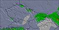
Image: Central Europe snow forecast for the next 3 days.
NORTH AMERICA
NORTH AMERICA INTRO
A calmer week across North America than we’ve seen for much of January, with some snowfall across the continent’s ski slopes, but most bringing just a few inches rather than the feet of fresh snow we saw in other weeks earlier this month. That being said, the next big front is just moving into the west and is expected to deliver several feet more snowfall by the weekend. January is certainly ending much better than it began for most ski areas across Canada and the US, with the majority (although with a few notable exceptions) now posting 80-100% of their terrain open, compared to most having only 50% open, on average, four weeks ago.
ROCKIES REPORT
Not much fresh snowfall this week and temperatures getting a little warm on the lower slopes but not looking too bad either, especially considering the season so far. Colorado’s Keystone was celebrating at the weekend as it managed to open all 140 of its runs for the first time this season and thanked its staff for their hard work in making that happen. Most other ski areas in the Rockies are now almost fully open, Vail (28/52” / 70/127cm) for example posting 98% of their slopes skiable and America’s biggest ski area Park City Mountain (45/66” / 112/165cm) resort in Utah posting that its 100% open for the third successive week. However, it’s not good news everywhere, Montana continues to play catch up on snow cover with another of America’s biggest areas, Big Sky (24/32” / 60/80cm), still reporting less than half of its slopes open.
ROCKIES FORECAST
Continuing sunny weather in the coming week, with daytime temperatures at mountain bases getting into the 40s Fahrenheit, although remaining subzero on higher slopes and overnight. The next hope of change is coming at the weekend when a fresh front should bring moderate snowfall from Friday onwards.
USA WEST REPORT
It has been a fairly dry week across the western US compared to the snowy first half of January, but a new front is starting to move in as we publish this week’s report, beginning what will hopefully be a quite significant snowfall lasting through much of the coming week. Conditions do remain about the best they’ve been all winter however, with most centres now 60-90% open. Mammoth (50/82” / 125/205cm) is at 75% open and nearing seven feet deep for its upper slopes snow depth. However, Timberline (78/116″ / 195/290cm), in Oregon to the north, has the region’s deepest snowpack, albeit currently down a little on a week ago when it had reached 10 feet (3m).
USA WEST FORECAST
It looks like there’s a good snowfall heading for the west coast to end this week, with the potential for several feet (60cm+) accumulating by Sunday, but snowfall continuing into next week to get February off to a good start.
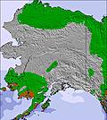
Image: Alaska snow forecast for the next 3 days.
MIDWEST REPORT
There are variable conditions across the Midwest at the moment, with some snowfall and also periods of warmer temperatures reported. Conditions are about the best they have been in this rather lacklustre winter so far though, with most centres in the region having at least half of their slopes open. Ski Brule (48/56″ / 120/140cm) is reporting the deepest snowpack in the region and all of its slopes are open. Fellow Michigan ski area Big Powderhorn Mountain (36/48” / 90/120cm) has had one of the biggest reported snowfalls of the past few days, getting seven inches (18cm) of fresh snowfall to start the week. It only reports 40% of its slopes open though.
MIDWEST FORECAST
Temperatures remaining in a range between the low 20s and high 30s, with not much (or in fact any) snow forecast and thawing warm weather in the daytime.
USA EAST REPORT
Overall, it continues to be a much better picture in the east than we saw in November and December, with the January transformation to more reliable snow cover continuing, but a further episode of rain and mild temperatures impacted cover and quality a little. This was quickly overwritten by fresh snowfall and most centres are between 50 and 90% open; however, Sunday River (28/32” / 70/80cm), in Maine, continues to recover lost ground from the heavy rain before Christmas and is now back up to 70% open. Although still posting a thin base, Killington (8/16” / 20/41cm), in Vermont, is reporting it somehow has 95% of its slopes open, most of which are in the east.
USA EAST FORECAST
Staying cold with mostly light snowfall expected. Highs around freezing, lows into the teens Fahrenheit. Overcast skies through the week, but more sunshine is expected at the weekend.
CANADA
CANADA WEST REPORT
A fairly quiet week on Canadian ski slopes with temperatures down around freezing at resort level, dropping to minus 10-12C overnight on high slopes. There have been quite a lot of overcast, low-light days with just a centimetre (2″) of fresh snowfall most mornings on the ski slopes of Alberta and BC. Warm weather has impacted the snowpack at some resorts however, causing some instability on steep runs. Most of these are currently 80-95% open, with Whistler Blackcomb (5/156cm / 2/62”) still posting 90% of its terrain open, the most in North America, although its lower base has thinned a bit over the past seven days.
CANADA WEST FORECAST
The next few days are expected to bring unsettled conditions with some light snowfall before a largely sunny end to the week and the start of February. Following this, more light snowfall is forecast to start the new week, with temperatures ranging from highs just above freezing to lows of -10 to -15C.
CANADA EAST REPORT
It’s been cold but mostly dry in Ontario and Quebec over the past seven days with a sunny start to the week. Temperatures have been in the range of -5 to -20C, which has kept the snow in good shape and enabled more snowfall. With the improved weather, ski areas are reporting the most terrain they’ve had open all season. Tremblant (0/130cm / 0/52”) claims it’s up to 99% open and Quebec’s second biggest centre, Mont Saine Anne (50/70cm / 20/28”), is up to 75% open; up from less than half of its slopes a few weeks ago.
CANADA EAST FORECAST
The next few days should see temperatures climb up closer to freezing and unsettled weather brings cloudy skies and 5-15cm (2-6″) of snowfall across the east. Colder, sunnier weather predicted to end the week.
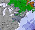
Image: East USA/ Canada snow forecast for the next 3 days.
ASIA
JAPAN REPORT
The snow has kept falling across northern Japan over the past week, with ski areas across Hokkaido seeing 5-20cm (2-8″) of snowfall most days. On Honshu, to the south, there’s been more sunshine, but also fresh snowfall some days too. Most Japanese areas are reporting their slopes 70-100% open with Niseko (115/305cm / 46/122″) reporting the deepest base of the country’s larger centres.
JAPAN FORECAST
Remaining cold with daytime highs at resort level a degree or two above freezing, and overnight lows up high touching -20C. Continuing snowfall most days of 5-15cm (2-6”).
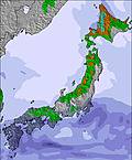
Image: Japan snow forecast for the next 3 days.