


Global Weekly Snow Roundup #318
Weekly Snow News for the world, updated 11 June 2026: Australia's season begins, Val d’Isère reopens and major snowfall is forecast for the Andes.

Next 4 days weather summary:Light rain (total 4.0mm), mostly falling on Sun afternoon. Warm (max 24°C on Sat afternoon, min 8°C on Sun night). Winds increasing (light winds from the W on Sat night, fresh winds from the SW by Sun afternoon). | Days 5-7 weather summary:Moderate rain (total 13.0mm), heaviest on Wed night. Warm (max 22°C on Wed afternoon, min 11°C on Mon night). Winds increasing (light winds from the W on Mon night, strong winds from the SW by Thu morning). | |||||||||||||||
Saturday 13 | Sunday 14 | Monday 15 | Tuesday 16 | Wednesday 17 | ||||||||||||
night | AM | PM | night | AM | PM | night | AM | PM | night | AM | PM | night | AM | PM | night | |
clear | clear | clear | clear | some clouds | light rain | rain shwrs | some clouds | some clouds | some clouds | cloudy | cloudy | some clouds | clear | light rain | light rain | |
km/h | ||||||||||||||||
Snow map | 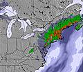 | 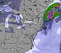 | 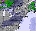 | 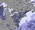 |  |  | ||||||||||
— | — | — | — | — | — | — | — | — | — | — | — | — | — | — | — | |
— | — | — | — | — | 2 | 2 | — | — | — | — | — | — | — | 2 | 5 | |
max °C | 20 | 20 | 24 | 21 | 22 | 19 | 18 | 14 | 18 | 16 | 16 | 20 | 17 | 20 | 22 | 17 |
min °C | 14 | 17 | 23 | 17 | 19 | 18 | 8 | 10 | 16 | 11 | 13 | 19 | 13 | 16 | 18 | 17 |
13 | 16 | 23 | 16 | 19 | 17 | 5 | 7 | 16 | 9 | 12 | 19 | 11 | 15 | 17 | 16 | |
70 | 52 | 35 | 61 | 51 | 86 | 84 | 47 | 36 | 63 | 54 | 39 | 74 | 60 | 83 | 92 | |
3850 | 3850 | 3750 | 4050 | 4150 | 4250 | 3750 | 3650 | 2750 | 3100 | 2800 | 2850 | 2900 | 3450 | 3550 | 3950 | |
— | 5:33 | — | — | 5:33 | — | — | 5:33 | — | — | 5:33 | — | — | 5:33 | — | — | |
— | — | — | 8:43 | — | — | 8:44 | — | — | 8:44 | — | — | 8:45 | — | — | 8:45 | |
Go pro and carve into:
Avalanche information: National Avalanche Center
Latest snow reports near Ski Sawmill:
| Top snow depth: | — |
|---|---|
| Bottom snow depth: | — |
| Fresh snowfall depth: | — |
| Last snowfall: | 16 Mar 2026 |
| Snow Alerts | Create Alert |
0.0 | Bluebird Powder days Fresh snow, mostly sunny, light wind. |
|---|---|
0.0 | Powder days Fresh snow, limited sun, any wind. |
0.0 | Bluebird days Average snow, mostly sunny, light wind. |
The above table gives the weather forecast for Ski Sawmill at the specific elevation of 675 m. Our sophisticated weather models allow us to provide snow forecasts for the top, middle and bottom ski stations of Ski Sawmill. To access the weather forecasts for the other elevations, use the tab navigation above the table. For a wider view of the weather, check out the Weather Map of United States.
Click here to read further information on freezing levels and how we forecast our temperatures.
My family went tubing at Ski Sawmill. It's the first time in forever that I've done anything like this due to me having MS. The personnel running the tubing run were amazing. My husband mentioned my disability letting them know I wasn't just being lazy by not getting in and out of the tube and someone assisting me and from there the tubing personnel were very understanding and helped every moment they had a chance. We travel often and usually I sit out of things since it is difficult for me without assistance and a lot of people are not understanding of disabilities and make you feel like you are just being lazy or bothering them with needing assistance. My entire family had a great time and that is due a lot in part to the great personnel. We will be coming back. Thank you.
Kelly Markle from United States writes:
My family went tubing at Ski Sawmill. It's the first time in forever that I've done anything like this due to me having MS. The personnel running the tubing run were amazing. My husband mentioned my disability letting them know I wasn't just being lazy by not getting in and out of the tube and someone assisting me and from there the tubing personnel were very understanding and helped every moment they had a chance. We travel often and usually I sit out of things since it is difficult for me without assistance and a lot of people are not understanding of disabilities and make you feel like you are just being lazy or bothering them with needing assistance. My entire family had a great time and that is due a lot in part to the great personnel. We will be coming back. Thank you.


 Nearest