

Global Weekly Snow Roundup #318
Weekly Snow News for the world, updated 11 June 2026: Australia's season begins, Val d’Isère reopens and major snowfall is forecast for the Andes.

Next 3 days weather summary:Light rain (total 4.0mm), mostly falling on Sun night. Warm (max 20°C on Sat afternoon, min 11°C on Fri morning). Wind will be generally light. | Days 4-6 weather summary:Moderate rain (total 16.0mm), heaviest on Mon afternoon. Very mild (max 19°C on Wed afternoon, min 12°C on Mon afternoon). Wind will be generally light. | |||||||||||||||||
Friday 12 | Saturday 13 | Sunday 14 | Monday 15 | Tuesday 16 | Wednesday 17 | |||||||||||||
AM | PM | night | AM | PM | night | AM | PM | night | AM | PM | night | AM | PM | night | AM | PM | night | |
clear | clear | clear | clear | some clouds | clear | some clouds | some clouds | rain shwrs | t-storm risk | mod. rain | rain shwrs | clear | cloudy | rain shwrs | clear | light rain | some clouds | |
km/h | ||||||||||||||||||
Snow map |  |  |  | 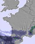 |  |  | ||||||||||||
— | — | — | — | — | — | — | — | — | — | — | — | — | — | — | — | — | — | |
— | — | — | — | — | — | — | — | 4 | 1 | 10 | 1 | — | — | 2 | — | 2 | — | |
max °C | 15 | 19 | 16 | 17 | 20 | 19 | 18 | 20 | 17 | 16 | 15 | 13 | 15 | 17 | 15 | 16 | 19 | 18 |
min °C | 11 | 18 | 13 | 14 | 19 | 15 | 16 | 19 | 13 | 14 | 12 | 12 | 12 | 17 | 13 | 14 | 19 | 14 |
10 | 18 | 13 | 14 | 19 | 15 | 16 | 19 | 13 | 14 | 12 | 12 | 12 | 17 | 13 | 14 | 19 | 14 | |
34 | 40 | 56 | 46 | 39 | 39 | 39 | 40 | 69 | 56 | 79 | 67 | 48 | 58 | 65 | 61 | 50 | 51 | |
4300 | 4300 | 4300 | 4150 | 4300 | 4200 | 4100 | 4250 | 3900 | 3900 | 3950 | 3900 | 3800 | 4100 | 4050 | 4100 | 4350 | 4300 | |
6:22 | — | — | 6:22 | — | — | 6:22 | — | — | 6:22 | — | — | 6:22 | — | — | 6:22 | — | — | |
— | — | 9:38 | — | — | 9:38 | — | — | 9:39 | — | — | 9:39 | — | — | 9:40 | — | — | 9:40 | |
Go pro and carve into:
Avalanche information: European Avalanche Warning Services (EAWS)
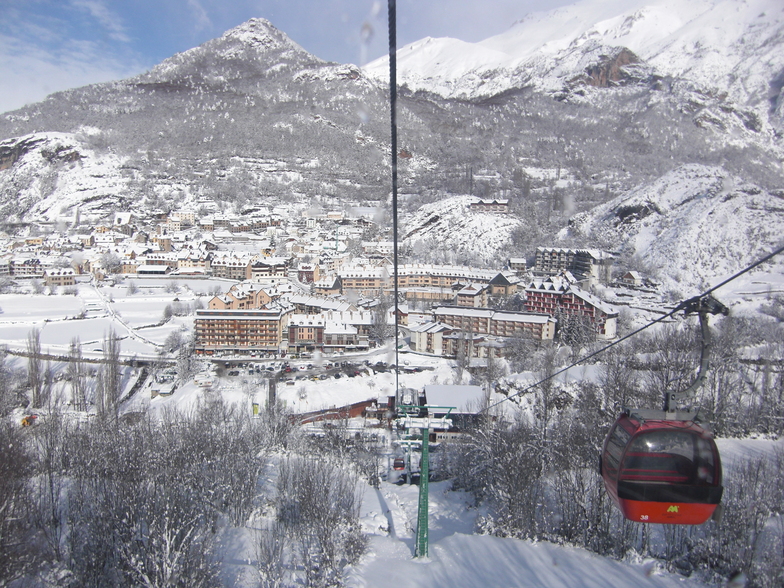
Latest snow reports near Panticosa:
| Top snow depth: | 0 cm |
|---|---|
| Bottom snow depth: | 0 cm |
| Fresh snowfall depth: | — |
| Last snowfall: | 15 May 2026 |
| Snow Alerts | Create Alert |
0.0 | Bluebird Powder days Fresh snow, mostly sunny, light wind. |
|---|---|
0.0 | Powder days Fresh snow, limited sun, any wind. |
0.0 | Bluebird days Average snow, mostly sunny, light wind. |
The above table gives the weather forecast for Panticosa at the specific elevation of 1876 m. Our sophisticated weather models allow us to provide snow forecasts for the top, middle and bottom ski stations of Panticosa. To access the weather forecasts for the other elevations, use the tab navigation above the table. For a wider view of the weather, check out the Weather Map of Spain.
Click here to read further information on freezing levels and how we forecast our temperatures.
Overall 3.8 Based on 35 votes and 5 reviews
Bonita estación con vista a montes del Infierno mas de tres mil metros . El pueblo típico del Pirineo. Hay hoteles restaurantes tiendas . Tiene todo los necesario que busca un turista. Muy recomendable ,sobre todo para familias con niños. Pista fáciles y difíciles muy variadas, Espectacular pista que baja hasta el mismo pueblo. Se aprecia amabilidad y ganas de agradar en los nativos
Feliz Cuesta from Spain writes:
Bonita estación con vista a montes del Infierno mas de tres mil metros . El pueblo típico del Pirineo. Hay hoteles restaurantes tiendas . Tiene todo los necesario que busca un turista.
Muy recomendable ,sobre todo para familias con niños.
Pista fáciles y difíciles muy variadas, Espectacular pista que baja hasta el mismo pueblo.
Se aprecia amabilidad y ganas de agradar en los nativos


 Nearest