


Global Weekly Snow Roundup #318
Weekly Snow News for the world, updated 11 June 2026: Australia's season begins, Val d’Isère reopens and major snowfall is forecast for the Andes.

Next 4 days weather summary:Mostly dry. Very mild (max 18°C on Sat afternoon, min 13°C on Fri night). Winds decreasing (fresh winds from the NE on Sun night, light winds from the NNE by Mon afternoon). | Days 5-7 weather summary:Mostly dry. Warm (max 23°C on Thu afternoon, min 15°C on Mon night). Wind will be generally light. | |||||||||||||||
Saturday 13 | Sunday 14 | Monday 15 | Tuesday 16 | Wednesday 17 | ||||||||||||
night | AM | PM | night | AM | PM | night | AM | PM | night | AM | PM | night | AM | PM | night | |
clear | clear | some clouds | some clouds | some clouds | some clouds | clear | clear | clear | clear | clear | some clouds | some clouds | clear | clear | clear | |
km/h | ||||||||||||||||
Snow map | 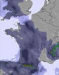 | 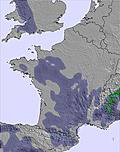 | 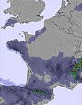 | 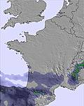 |  |  | ||||||||||
— | — | — | — | — | — | — | — | — | — | — | — | — | — | — | — | |
— | — | — | — | — | — | — | — | — | — | — | — | — | — | — | — | |
max °C | 15 | 14 | 18 | 18 | 16 | 18 | 18 | 14 | 18 | 17 | 15 | 19 | 19 | 18 | 21 | 22 |
min °C | 13 | 14 | 17 | 16 | 15 | 17 | 15 | 14 | 16 | 15 | 15 | 17 | 17 | 18 | 20 | 20 |
11 | 12 | 16 | 14 | 15 | 17 | 13 | 13 | 16 | 14 | 15 | 17 | 16 | 18 | 20 | 20 | |
58 | 49 | 32 | 38 | 41 | 30 | 39 | 44 | 33 | 36 | 41 | 35 | 36 | 41 | 34 | 35 | |
4100 | 4050 | 4000 | 3950 | 3800 | 3700 | 3800 | 3650 | 3500 | 3700 | 3650 | 3750 | 4050 | 3900 | 4200 | 4150 | |
— | 5:58 | — | — | 5:58 | — | — | 5:58 | — | — | 5:58 | — | — | 5:58 | — | — | |
— | — | — | 9:37 | — | — | 9:37 | — | — | 9:38 | — | — | 9:38 | — | — | 9:39 | |
Go pro and carve into:
Avalanche information: European Avalanche Warning Services (EAWS)
Latest snow reports near Le Mont-Dore:
| Top snow depth: | 0 cm |
|---|---|
| Bottom snow depth: | 0 cm |
| Fresh snowfall depth: | — |
| Last snowfall: | 16 May 2026 |
| Snow Alerts | Create Alert |
0.0 | Bluebird Powder days Fresh snow, mostly sunny, light wind. |
|---|---|
0.0 | Powder days Fresh snow, limited sun, any wind. |
0.0 | Bluebird days Average snow, mostly sunny, light wind. |
The above table gives the weather forecast for Le Mont-Dore at the specific elevation of 1526 m. Our sophisticated weather models allow us to provide snow forecasts for the top, middle and bottom ski stations of Le Mont-Dore. To access the weather forecasts for the other elevations, use the tab navigation above the table. For a wider view of the weather, check out the Weather Map of France.
Click here to read further information on freezing levels and how we forecast our temperatures.
Overall 3.8 Based on 17 votes and 3 reviews
My wife and I are both retired but enjoy our skiing. We have skied in Le Mont Dore for the past few years and have found it perfect for our needs. The people are really friendly and the ski staff are very helpful. Lift passes are very reasonable and flexible. The town, itself, is very good for shopping and, again, the people are very friendly. We have a property near Bellac so travelling to the resort takes around two hours using mostly motorways. If you need other Brits around you, you will be disappointed. This is mostly a French ski resort but we have found everyone friendly on and off the piste. As a retired ski coach, I can recommend Mont Dore to all levels but it is especially good for beginners and intermediates. Alan Bainbridge
alan bainbridge from United Kingdom writes:
My wife and I are both retired but enjoy our skiing. We have skied in Le Mont Dore for the past few years and have found it perfect for our needs. The people are really friendly and the ski staff are very helpful. Lift passes are very reasonable and flexible. The town, itself, is very good for shopping and, again, the people are very friendly.
We have a property near Bellac so travelling to the resort takes around two hours using mostly motorways. If you need other Brits around you, you will be disappointed. This is mostly a French ski resort but we have found everyone friendly on and off the piste.
As a retired ski coach, I can recommend Mont Dore to all levels but it is especially good for beginners and intermediates.
Alan Bainbridge


 Nearest