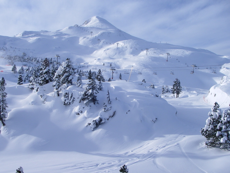


Global Weekly Snow Roundup #318
Weekly Snow News for the world, updated 11 June 2026: Australia's season begins, Val d’Isère reopens and major snowfall is forecast for the Andes.

Next 3 days weather summary:Light rain (total 5.0mm), mostly falling on Sun night. Very mild (max 19°C on Sat night, min 14°C on Fri afternoon). Wind will be generally light. | Days 4-6 weather summary:Light rain (total 7.0mm), mostly falling on Mon afternoon. Warm (max 20°C on Wed afternoon, min 13°C on Mon night). Wind will be generally light. | ||||||||||||||||
Fri 12 | Saturday 13 | Sunday 14 | Monday 15 | Tuesday 16 | Wednesday 17 | ||||||||||||
PM | night | AM | PM | night | AM | PM | night | AM | PM | night | AM | PM | night | AM | PM | night | |
clear | clear | clear | clear | clear | some clouds | some clouds | t-storm risk | t-storm risk | t-storm risk | rain shwrs | clear | t-storm risk | clear | clear | some clouds | clear | |
km/h | |||||||||||||||||
Snow map | 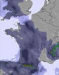 | 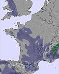 | 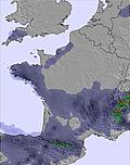 | 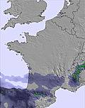 |  |  | |||||||||||
— | — | — | — | — | — | — | — | — | — | — | — | — | — | — | — | — | |
— | — | — | — | — | — | — | 4 | 1 | 4 | 2 | — | 1 | — | — | — | — | |
max °C | 15 | 16 | 17 | 18 | 19 | 18 | 18 | 17 | 14 | 15 | 14 | 14 | 15 | 16 | 17 | 20 | 19 |
min °C | 14 | 14 | 15 | 18 | 18 | 18 | 18 | 14 | 14 | 14 | 13 | 13 | 15 | 15 | 16 | 19 | 18 |
13 | 13 | 15 | 18 | 18 | 18 | 18 | 14 | 14 | 13 | 13 | 13 | 15 | 15 | 16 | 19 | 18 | |
50 | 48 | 40 | 45 | 32 | 35 | 50 | 64 | 63 | 69 | 67 | 56 | 65 | 54 | 53 | 45 | 40 | |
4400 | 4300 | 4250 | 4200 | 4150 | 4100 | 4200 | 3950 | 3900 | 3900 | 3900 | 3900 | 4050 | 4100 | 4150 | 4300 | 4250 | |
— | — | 6:22 | — | — | 6:22 | — | — | 6:22 | — | — | 6:22 | — | — | 6:22 | — | — | |
— | 9:42 | — | — | 9:42 | — | — | 9:43 | — | — | 9:43 | — | — | 9:43 | — | — | 9:44 | |
Go pro and carve into:
Avalanche information: European Avalanche Warning Services (EAWS)
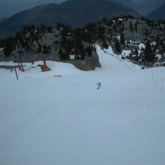
Latest snow reports near La Pierre Saint Martin:
| Top snow depth: | 0 cm |
|---|---|
| Bottom snow depth: | 0 cm |
| Fresh snowfall depth: | — |
| Last snowfall: | 16 May 2026 |
| Snow Alerts | Create Alert |
0.0 | Bluebird Powder days Fresh snow, mostly sunny, light wind. |
|---|---|
0.0 | Powder days Fresh snow, limited sun, any wind. |
0.0 | Bluebird days Average snow, mostly sunny, light wind. |
The above table gives the weather forecast for La Pierre Saint Martin at the specific elevation of 1825 m. Our sophisticated weather models allow us to provide snow forecasts for the top, middle and bottom ski stations of La Pierre Saint Martin. To access the weather forecasts for the other elevations, use the tab navigation above the table. For a wider view of the weather, check out the Weather Map of France.
Click here to read further information on freezing levels and how we forecast our temperatures.
Overall 3.7 Based on 34 votes and 8 reviews
Petite station familiale très agréable. Bon rapport qualité-prix. Pistes toutes découvertes en 2 jours. Accès aisé par l'aéroport de Pau et bus quotidiens bon marché depuis Oloron et Arette. Hors piste possible mais bien se renseigner car grosses crevasses. Nécessairement trilingue du fait de la proximité espagnole, nombreux les fins de semaine, et des nombreux anglais résidant dans la région. Bonne école de ski.
François Saint from France writes:
Petite station familiale très agréable. Bon rapport qualité-prix. Pistes toutes découvertes en 2 jours. Accès aisé par l'aéroport de Pau et bus quotidiens bon marché depuis Oloron et Arette. Hors piste possible mais bien se renseigner car grosses crevasses. Nécessairement trilingue du fait de la proximité espagnole, nombreux les fins de semaine, et des nombreux anglais résidant dans la région. Bonne école de ski.
Read 7 more reviews of La Pierre Saint Martin or submit your own


 Nearest