

Global Weekly Snow Roundup #318
Weekly Snow News for the world, updated 11 June 2026: Australia's season begins, Val d’Isère reopens and major snowfall is forecast for the Andes.

Next 4 days weather summary:Heavy rain (total 24.0mm), heaviest during Sat morning. Very mild (max 10°C on Sun afternoon, min 2°C on Sun night). Winds increasing (light winds from the SE on Fri night, strong winds from the N by Sun night). | Days 5-7 weather summary:Light rain (total 3.0mm), mostly falling on Thu afternoon. Very mild (max 14°C on Thu afternoon, min 2°C on Mon night). Wind will be generally light. | |||||||||||||||
Saturday 13 | Sunday 14 | Monday 15 | Tuesday 16 | Wednesday 17 | ||||||||||||
night | AM | PM | night | AM | PM | night | AM | PM | night | AM | PM | night | AM | PM | night | |
light rain | heavy rain | light rain | light rain | light rain | cloudy | cloudy | cloudy | cloudy | cloudy | some clouds | clear | clear | clear | clear | some clouds | |
km/h | ||||||||||||||||
Snow map | 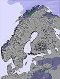 | 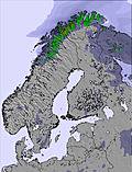 | 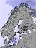 | 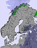 | 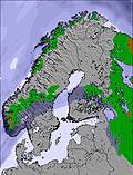 | 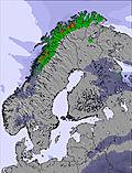 | ||||||||||
— | — | — | — | — | — | — | — | — | — | — | — | — | — | — | — | |
5 | 11 | 3 | 4 | 1 | — | — | — | — | — | — | — | — | — | — | — | |
max °C | 6 | 4 | 5 | 6 | 9 | 10 | 7 | 5 | 7 | 6 | 5 | 10 | 8 | 7 | 13 | 13 |
min °C | 4 | 4 | 5 | 5 | 7 | 10 | 2 | 3 | 7 | 2 | 3 | 8 | 4 | 5 | 11 | 10 |
-1 | 1 | 2 | 1 | 2 | 6 | -4 | -2 | 3 | -3 | -2 | 6 | 3 | 5 | 11 | 8 | |
99 | 99 | 97 | 94 | 68 | 47 | 67 | 66 | 58 | 73 | 54 | 37 | 68 | 62 | 40 | 63 | |
1800 | 1800 | 1900 | 2050 | 2200 | 2300 | 1700 | 1750 | 2000 | 1550 | 1800 | 2150 | 2000 | 2250 | 2500 | 2650 | |
— | 3:40 | — | — | 3:40 | — | — | 3:39 | — | — | 3:39 | — | — | 3:38 | — | — | |
— | — | — | 10:57 | — | — | 10:57 | — | — | 10:58 | — | — | 10:59 | — | — | 11:00 | |
Go pro and carve into:
Avalanche information: Varsom.no Avalanche Warnings
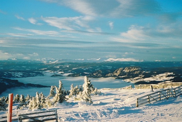
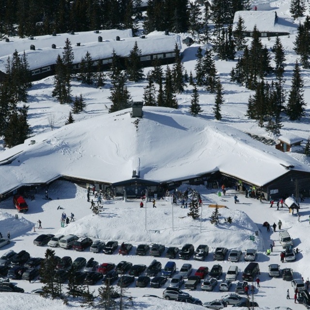
Latest snow reports near Hafjell:
| Top snow depth: | 0 cm |
|---|---|
| Bottom snow depth: | 0 cm |
| Fresh snowfall depth: | — |
| Last snowfall: | 14 May 2026 |
| Snow Alerts | Create Alert |
0.0 | Bluebird Powder days Fresh snow, mostly sunny, light wind. |
|---|---|
0.0 | Powder days Fresh snow, limited sun, any wind. |
0.0 | Bluebird days Average snow, mostly sunny, light wind. |
The above table gives the weather forecast for Hafjell at the specific elevation of 1059 m. Our sophisticated weather models allow us to provide snow forecasts for the top, middle and bottom ski stations of Hafjell. To access the weather forecasts for the other elevations, use the tab navigation above the table. For a wider view of the weather, check out the Weather Map of Norway.
Click here to read further information on freezing levels and how we forecast our temperatures.
Overall 4.5 Based on 13 votes and 8 reviews
I have been going to Hafjell for the past 4 Christmas's with over 100 Irish school children. The slopes are excellent as are instructors and staff, nothing ever seems too much trouble. We stay in Birbebeinern in Lilehammer,15mins from slopes. Excellent accomodation, food and staff. Back again in 4 weeks with another 100 young people...can't wait!!
paul collins from Ireland writes:
I have been going to Hafjell for the past 4 Christmas's with over 100 Irish school children. The slopes are excellent as are instructors and staff, nothing ever seems too much trouble. We stay in Birbebeinern in Lilehammer,15mins from slopes. Excellent accomodation, food and staff. Back again in 4 weeks with another 100 young people...can't wait!!


 Nearest