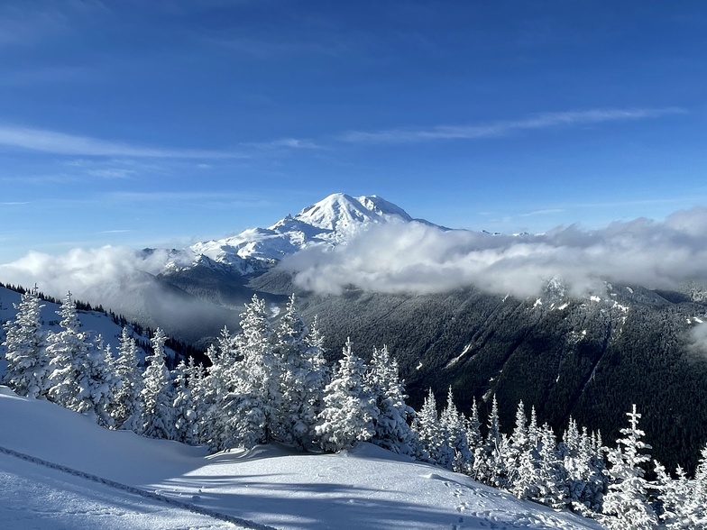


Global Weekly Snow Roundup #318
Weekly Snow News for the world, updated 11 June 2026: Australia's season begins, Val d’Isère reopens and major snowfall is forecast for the Andes.

Next 4 days weather summary:Mostly dry. Warm (max 24°C on Sun afternoon, min 4°C on Thu night). Wind will be generally light. | Days 5-7 weather summary:Light rain (total 2.0mm), mostly falling on Tue afternoon. Warm (max 23°C on Mon afternoon, min 6°C on Tue night). Wind will be generally light. | |||||||||||||||
Friday 12 | Saturday 13 | Sunday 14 | Monday 15 | Tuesday 16 | ||||||||||||
night | AM | PM | night | AM | PM | night | AM | PM | night | AM | PM | night | AM | PM | night | |
clear | some clouds | clear | clear | clear | clear | clear | clear | clear | some clouds | some clouds | some clouds | some clouds | some clouds | rain shwrs | clear | |
km/h | ||||||||||||||||
Snow map |  |  |  | 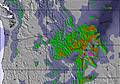 |  |  | ||||||||||
— | — | — | — | — | — | — | — | — | — | — | — | — | — | — | — | |
— | — | — | — | — | — | — | — | — | — | — | — | — | — | 2 | — | |
max °C | 11 | 13 | 16 | 11 | 19 | 21 | 16 | 22 | 24 | 18 | 22 | 23 | 17 | 17 | 16 | 12 |
min °C | 4 | 9 | 15 | 7 | 15 | 21 | 12 | 17 | 23 | 14 | 18 | 22 | 10 | 14 | 16 | 6 |
3 | 8 | 15 | 7 | 15 | 21 | 12 | 17 | 23 | 14 | 18 | 22 | 9 | 14 | 16 | 5 | |
71 | 43 | 34 | 44 | 27 | 31 | 45 | 26 | 33 | 32 | 32 | 28 | 50 | 71 | 60 | 89 | |
3600 | 3450 | 3550 | 3350 | 3350 | 3800 | 3850 | 3850 | 4400 | 4700 | 4650 | 4800 | 4550 | 4150 | 4300 | 4550 | |
— | 5:11 | — | — | 5:09 | — | — | 5:09 | — | — | 5:09 | — | — | 5:09 | — | — | |
— | — | — | 9:00 | — | — | 9:00 | — | — | 9:01 | — | — | 9:01 | — | — | 9:01 | |
Go pro and carve into:
Avalanche information: National Avalanche Center
Latest snow reports near Crystal Mountain:
| Top snow depth: | — |
|---|---|
| Bottom snow depth: | — |
| Fresh snowfall depth: | 10 cm |
| Last snowfall: | 9 Jun 2026 |
| Snow Alerts | Create Alert |
0.0 | Bluebird Powder days Fresh snow, mostly sunny, light wind. |
|---|---|
0.0 | Powder days Fresh snow, limited sun, any wind. |
0.0 | Bluebird days Average snow, mostly sunny, light wind. |
The above table gives the weather forecast for Crystal Mountain at the specific elevation of 1345 m. Our sophisticated weather models allow us to provide snow forecasts for the top, middle and bottom ski stations of Crystal Mountain. To access the weather forecasts for the other elevations, use the tab navigation above the table. For a wider view of the weather, check out the Weather Map of United States.
Click here to read further information on freezing levels and how we forecast our temperatures.
Overall 3.2 Based on 36 votes and 11 reviews
I would not recommend going to Crystal Mountain. For the price you pay, they don't deliver. They were mask nazis and even got in the faces of my friends 3 yr old and 8 yr old. The skiing wasn't that great either and the terrain park was poorly done. I also felt very limited because I got yelled at for going off groomed trails, or going in the terrain park but not going on any of the features. I was definitely underwhelmed by the skiing part and the people there were controlling, domineering and mask nazis.
Chris from United States writes:
I would not recommend going to Crystal Mountain. For the price you pay, they don't deliver. They were mask nazis and even got in the faces of my friends 3 yr old and 8 yr old. The skiing wasn't that great either and the terrain park was poorly done. I also felt very limited because I got yelled at for going off groomed trails, or going in the terrain park but not going on any of the features. I was definitely underwhelmed by the skiing part and the people there were controlling, domineering and mask nazis.


 Nearest