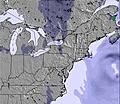
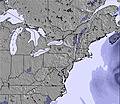
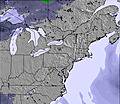
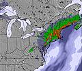
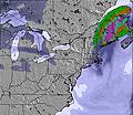
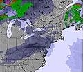
The above table gives the weather forecast for Thunder Ridge at the specific elevation of 296 m. Our sophisticated weather models allow us to provide snow forecasts for the top, middle and bottom ski stations of Thunder Ridge. To access the weather forecasts for the other elevations, use the tab navigation above the table. For a wider view of the weather, check out the Weather Map of United States.
Click here to read further information on freezing levels and how we forecast our temperatures.
I disagree with the review above. You take Thunder Ridge for what it is....very close (if you don't want to do a drive), inexpensive, and good just to do some skiing and enjoy being outside for a few hours. Thunder Ridge doesn't advertise as the 'resort' of the Northeast nor does it want to be. Great to go for a few hours of skiing and have fun with friends and family. You don't choose Thunder Ridge for challenging terrain and for a 3 mile train run, you go to practice your skiing and have some close to home fun. The review above doesn't get it! Also, this reviewer doesn't know his resorts and to even mention Jiminy Peak as a hidden gem is wrong. Everyone knows about that one including Butternut. Well.... I have a better one in the area and of course will not tell. Way better than Jiminy and Nut, more trails and no crowds. Do your homework if you want to know which resort I am referring to because I am not giving it away!
I disagree with the review above. You take Thunder Ridge for what it is....very close (if you don't want to do a drive), inexpensive, and good just to do some skiing and enjoy being outside for a few hours. Thunder Ridge doesn't advertise as the 'resort' of the Northeast nor does it want to be. Great to go for a few hours of skiing and have fun with friends and family. You don't choose Thunder Ridge for challenging terrain and for a 3 mile train run, you go to practice your skiing and have some close to home fun. The review above doesn't get it! Also, this reviewer doesn't know his resorts and to even mention Jiminy Peak as a hidden gem is wrong. Everyone knows about that one including Butternut. Well.... I have a better one in the area and of course will not tell. Way better than Jiminy and Nut, more trails and no crowds. Do your homework if you want to know which resort I am referring to because I am not giving it away!
Free Snow-Forecast.com weather widget for your website
Embed the Thunder Ridge weather widget on your site for free. It provides a weekly snapshot of snow and rain conditions across all elevations. Follow the two quick steps to grab your custom code and paste it into your site. Choose between metric or imperial units. Click here to get the code.


 Nearest