


View forecast
Moonlight Basin at 3124 m altitude
Issued by Snow-Forecast.com at: 11 am (local time) / 23 Apr 2024
Now
Tuesday 23 | Wednesday 24 | Thursday 25 | Friday 26 | Saturday 27 | Sunday 28 | Monday 29 | |||||||||||||||
AM | PM | night | AM | PM | night | AM | PM | night | AM | PM | night | AM | PM | night | AM | PM | night | AM | PM | night | |
some clouds | some clouds | some clouds | some clouds | some clouds | cloudy | light snow | light snow | heavy snow | light snow | light snow | light snow | mod. snow | light snow | light snow | light snow | snow shwrs | light snow | mod. snow | snow shwrs | snow shwrs | |
km/h | |||||||||||||||||||||
Snow map | 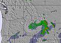 | 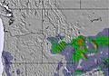 | 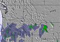 | 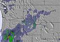 | 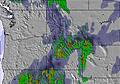 | 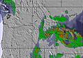 |  | ||||||||||||||
— | — | — | — | — | — | — | 2.0 | 14 | 3 | 3 | 3 | 6 | 2.0 | — | — | — | 1.0 | 7 | 4 | — | |
— | — | — | — | — | — | — | — | — | — | — | — | — | — | — | — | — | — | — | — | — | |
max°C | -4 | -1 | 1 | 1 | 3 | 2 | -2 | 0 | -2 | -4 | -4 | -5 | -5 | -5 | -5 | -6 | -5 | -4 | -6 | -8 | -9 |
min°C | -6 | -2 | -1 | 1 | 3 | -1 | -2 | -1 | -4 | -5 | -4 | -6 | -6 | -5 | -6 | -6 | -5 | -5 | -8 | -8 | -10 |
-6 | -6 | -4 | -2 | -1 | -4 | -5 | -3 | -8 | -5 | -4 | -10 | -8 | -8 | -9 | -11 | -11 | -12 | -18 | -20 | -17 | |
51 | 56 | 47 | 40 | 47 | 66 | 97 | 90 | 98 | 97 | 98 | 94 | 97 | 98 | 95 | 94 | 96 | 96 | 94 | 59 | 66 | |
2250 | 2900 | 3150 | 3250 | 3450 | 3250 | 2850 | 3100 | 2650 | 2450 | 2500 | 2300 | 2300 | 2450 | 2200 | 2250 | 2450 | 2300 | 2250 | 2150 | 800 | |
6:24 | — | — | 6:22 | — | — | 6:22 | — | — | 6:20 | — | — | 6:18 | — | — | 6:16 | — | — | 6:16 | — | — | |
— | 8:21 | — | — | 8:22 | — | — | 8:22 | — | — | 8:24 | — | — | 8:25 | — | — | 8:27 | — | — | 8:28 | — | |
Next 0-3 days weather summary:
A moderate fall of snow, heaviest on Thu night. Freeze-thaw conditions (max 3°C on Wed afternoon, min -6°C on Tue morning). Wind will be generally light.
Next 4-6 days weather summary:
A moderate fall of snow, heaviest on Sat morning. Temperatures will be below freezing (max -4°C on Fri morning, min -6°C on Fri night). Winds increasing (calm on Sat morning, fresh winds from the SW by Sun night).
Popular Moonlight Basin Pages
Snow Radar
Latest snow reports near Moonlight Basin:
Moonlight Basin Snow Conditions
| Top snow depth: | — |
|---|---|
| Bottom snow depth: | — |
| Fresh snowfall depth: | — |
| Last snowfall: | 19 Apr 2024 |
| Snow Alerts | Create Alert |
Other resorts in USA - Montana are reporting: powder (0) / good piste (0)
Snow-Forecast Partner Offers
Show your business here
Snow History
Week 4 of April has on average:
1.0 | Bluebird Powder days Fresh snow, mostly sunny, light wind. |
|---|---|
2.4 | Powder days Fresh snow, limited sun, any wind. |
0.7 | Bluebird days Average snow, mostly sunny, light wind. |
Moonlight Basin Forecast Snowfall


Other resorts in USA - Montana are reporting: powder (0) / good piste (0)
The above table gives the weather forecast for Moonlight Basin at the specific elevation of 3124 m. Our sophisticated weather models allow us to provide snow forecasts for the top, middle and bottom ski stations of Moonlight Basin. To access the weather forecasts for the other elevations, use the tab navigation above the table. For a wider view of the weather, check out the Weather Map of United States.
Click here to read further information on freezing levels and how we forecast our temperatures.
Visitor Reviews of Moonlight Basin
- CASA Tours from United States writes:
Moonlight Basin has some of the best in-bounds terrain in the United States. The Headwaters Traverse - aka the Lord of the Rings Traverse - accesses a plethora of steep, interesting terrain. The traverse alone gets the adrenalin juices flowing. The Spring Run-Off Challenge is one of the few big mountain free ride competitions in SW Montana. With a Lone Peak Pass skiers and snowboarders can ride both Big Sky and Moonlight, which means access to the North Summit Snowfield, one of the longest runs in North America, over 4000 vertical feet. Moonlight's patrol does an amazing job in getting their terrain open and really encourages folks to get after it. Moonlight is also an ideal place for families and beginners. With little to no crowds ever, Moonlight has lots of space to cruise. The only downside are some flat sections on the lower mountain. If you are looking to bang out laps the Headwaters chair and the Lone Tree Lift allow one to rack up vertical quickly. Moonlight has a cool local scene and offers a cheaper alternative to neighboring Big Sky. For apres the Moonlight Lodge is a classy place where you can still get a PBR and plate of Nachos on a dirtbag budget.
Visitor Reviews of Moonlight Basin
CASA Tours from United States writes:
Moonlight Basin has some of the best in-bounds terrain in the United States. The Headwaters Traverse - aka the Lord of the Rings Traverse - accesses a plethora of steep, interesting terrain. The traverse alone gets the adrenalin juices flowing. The Spring Run-Off Challenge is one of the few big mountain free ride competitions in SW Montana. With a Lone Peak Pass skiers and snowboarders can ride both Big Sky and Moonlight, which means access to the North Summit Snowfield, one of the longest runs in North America, over 4000 vertical feet. Moonlight's patrol does an amazing job in getting their terrain open and really encourages folks to get after it.
Moonlight is also an ideal place for families and beginners. With little to no crowds ever, Moonlight has lots of space to cruise. The only downside are some flat sections on the lower mountain.
If you are looking to bang out laps the Headwaters chair and the Lone Tree Lift allow one to rack up vertical quickly.
Moonlight has a cool local scene and offers a cheaper alternative to neighboring Big Sky. For apres the Moonlight Lodge is a classy place where you can still get a PBR and plate of Nachos on a dirtbag budget.
Free Snow-Forecast.com weather widget for your website
The Moonlight Basin skiing weather widget is available to embed on external websites free of charge. It provides a daily summary of our Moonlight Basin snow forecast and current weather conditions. Simply go to the feed configuration page and follow the 3 simple steps to grab the custom html code snippet and paste it into your own site. You can choose the snow forecast elevation (summit, mid-mountain or bottom lift) and metric/imperial units for the snow forecast feed to suit your own website…. Click here to get the code.
View detailed snow forecast for Moonlight Basin at:
snow-forecast.com

 Nearest