
Ski Hire by Intersport
Click here for discount

Bad Hofgastein Weather (Next 3 days): The snow forecast for Bad Hofgastein is: A light covering of new snow, mostly falling on Wed night. Temperatures will be below freezing (max 0°C on Sat afternoon, min -10°C on Wed night). Wind will be generally light.
Bad Hofgastein Weather (Days 4-6): Mostly dry. Freeze-thaw conditions (max 9°C on Mon afternoon, min 0°C on Sat night). Wind will be generally light.
| Resort | Snow Depth | Temp. (°C) | Wind (km/h) | Weather | ||
|---|---|---|---|---|---|---|
| Top Lift: | 0.0 m | -9 | ||||
| Middle Lift: | -4 | |||||
| Bottom Lift: | 0.0 m | 1 |
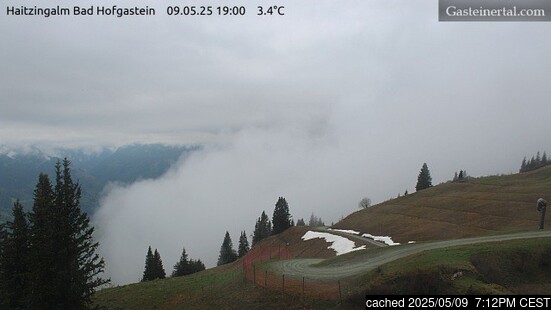
Latest snow reports near Bad Hofgastein:
Light rain showers reported from Obertauern (automatic) at 1742 metres elevation one km N of Obertauern but it is forecast cold enough for snow at the ski area from Obertauern
Light rain showers reported from Katschberg at 1637 metres elevation one km NNE of Katschberg-Aineck but it is forecast cold enough for snow at the ski area from Katschberg-Aineck
Rain reported from Lienz at 238 metres elevation only 4 kms SSE of Lienz/Zettersfeld but it is forecast cold enough for snow at the ski area from Lienz/Zettersfeld

Thursday 25 | Friday 26 | Saturday 27 | Sunday 28 | Monday 29 | Tuesday 30 | ||||||||||||||
night | AM | PM | night | AM | PM | night | AM | PM | night | AM | PM | night | AM | PM | night | AM | PM | night | |
light snow | snow shwrs | light snow | snow shwrs | clear | light snow | snow shwrs | clear | some clouds | clear | some clouds | some clouds | some clouds | some clouds | clear | clear | clear | clear | some clouds | |
km/h | |||||||||||||||||||
Snow map |  |  |  |  |  |  |  | ||||||||||||
4 | — | 2.0 | — | — | — | — | — | — | — | — | — | — | — | — | — | — | — | — | |
— | — | — | — | — | — | — | — | — | — | — | — | — | — | — | — | — | — | — | |
max°C | -8 | -8 | -5 | -6 | -3 | -2 | -3 | -1 | 0 | 1 | 4 | 6 | 5 | 7 | 9 | 7 | 8 | 8 | 6 |
min°C | -10 | -9 | -6 | -6 | -5 | -3 | -4 | -2 | 0 | 0 | 2 | 5 | 4 | 5 | 8 | 4 | 5 | 8 | 4 |
-14 | -12 | -8 | -9 | -8 | -6 | -8 | -5 | -4 | -5 | -1 | 2 | 0 | 3 | 6 | 0 | 2 | 5 | 0 | |
84 | 81 | 88 | 68 | 58 | 76 | 68 | 57 | 70 | 74 | 54 | 54 | 59 | 41 | 49 | 48 | 49 | 59 | 60 | |
750 | 1350 | 1700 | 900 | 1800 | 2000 | 1250 | 2200 | 2350 | 2250 | 3150 | 3450 | 3500 | 3350 | 3350 | 3350 | 3250 | 3200 | 3150 | |
— | 6:00 | — | — | 5:58 | — | — | 5:56 | — | — | 5:54 | — | — | 5:54 | — | — | 5:52 | — | — | |
— | — | — | 8:09 | — | — | 8:10 | — | — | 8:13 | — | — | 8:14 | — | — | 8:15 | — | — | 8:16 | |
A light covering of new snow, mostly falling on Wed night. Temperatures will be below freezing (max 0°C on Sat afternoon, min -10°C on Wed night). Wind will be generally light.
Mostly dry. Freeze-thaw conditions (max 9°C on Mon afternoon, min 0°C on Sat night). Wind will be generally light.
Latest snow reports near Bad Hofgastein:
Light rain showers reported from Obertauern (automatic) at 1742 metres elevation one km N of Obertauern but it is forecast cold enough for snow at the ski area from Obertauern
Light rain showers reported from Katschberg at 1637 metres elevation one km NNE of Katschberg-Aineck but it is forecast cold enough for snow at the ski area from Katschberg-Aineck
Rain reported from Lienz at 238 metres elevation only 4 kms SSE of Lienz/Zettersfeld but it is forecast cold enough for snow at the ski area from Lienz/Zettersfeld
| Top snow depth: | 0 cm |
|---|---|
| Bottom snow depth: | 0 cm |
| Fresh snowfall depth: | 13 cm |
| Last snowfall: | 23 Apr 2024 |
| Snow Alerts | Create Alert |
0.2 | Bluebird Powder days Fresh snow, mostly sunny, light wind. |
|---|---|
1.2 | Powder days Fresh snow, limited sun, any wind. |
0.4 | Bluebird days Average snow, mostly sunny, light wind. |


The above table gives the weather forecast for Bad Hofgastein at the specific elevation of 2300 m. Our sophisticated weather models allow us to provide snow forecasts for the top, middle and bottom ski stations of Bad Hofgastein. To access the weather forecasts for the other elevations, use the tab navigation above the table. For a wider view of the weather, check out the Weather Map of Austria.
Click here to read further information on freezing levels and how we forecast our temperatures.
Overall 3.9 Based on 11 votes and 13 reviews
All the reviews on here are ancient! So thought we would update you. The skiing in the Gastein Valley is awesome! The lift system has greatly improved and we really love the skiing from Dorfgastein over to Wassarl, fab restaurants, very uncrowded and the most amazing sweeping long runs all the way to Wassarl. From Bad hofgastein you can reach the whole valley, even sportgastein, which is great for late season of poorer snow conditions..its high! Badhofgastein offer a great thermal spa and many local hotels include entry, its one of the best we have even visited a great way to spend the day for non skiers. If you have a car the ski pass covers the whole ski amade system and its well worth the drive to Deinten where you can access the whole Hochkonig area, which is huge and great skiing for those liking big long blue runs!
Barband Stew from United Kingdom writes:
All the reviews on here are ancient! So thought we would update you.
The skiing in the Gastein Valley is awesome! The lift system has greatly improved and we really love the skiing from Dorfgastein over to Wassarl, fab restaurants, very uncrowded and the most amazing sweeping long runs all the way to Wassarl. From Bad hofgastein you can reach the whole valley, even sportgastein, which is great for late season of poorer snow conditions..its high! Badhofgastein offer a great thermal spa and many local hotels include entry, its one of the best we have even visited a great way to spend the day for non skiers.
If you have a car the ski pass covers the whole ski amade system and its well worth the drive to Deinten where you can access the whole Hochkonig area, which is huge and great skiing for those liking big long blue runs!
The Bad Hofgastein skiing weather widget is available to embed on external websites free of charge. It provides a daily summary of our Bad Hofgastein snow forecast and current weather conditions. Simply go to the feed configuration page and follow the 3 simple steps to grab the custom html code snippet and paste it into your own site. You can choose the snow forecast elevation (summit, mid-mountain or bottom lift) and metric/imperial units for the snow forecast feed to suit your own website…. Click here to get the code.
View detailed snow forecast for Bad Hofgastein at:
snow-forecast.com


 Nearest